Market Trends of US Satellite-based Earth Observation Industry
Increasing Use of Satellites for Advanced Environmental Monitoring
- The United States has recently been increasingly utilizing satellite technology for advanced environmental monitoring. Satellites provide valuable data and insights for understanding and managing various aspects of the environment, including climate change, weather patterns, natural disasters, and land use.
- Weather Satellites are an important observational tool for all scales of National Weather Service (NWS) forecasting operations. The satellites provide real-time imagery and data on cloud cover, atmospheric conditions, and other meteorological variables. This information is vital for accurate weather forecasting, severe storm tracking, and issuing timely warnings for events like hurricanes, tornadoes, and blizzards.
- For instance, in 2022, Maxar Technologies, a provider of complete space solutions, was awarded a National Aeronautics and Space Administration (NASA) Phase A research contract for the National Oceanic and Atmospheric Administration's (NOAA) Geostationary Extended Observations (GeoXO) Spacecraft project. Under this project, Maxar will develop necessary mature technologies, conduct analysis on robotic servicing and payload accommodations and spacecraft concept, and help define the potential performance, risks, costs, and development schedule for a three-satellite, next-generation constellation of weather monitoring satellites.
- Moreover, with the growing concern about air quality in the United States, the government in the United States is launching satellites that can measure various air pollutants, including aerosols, ozone, and nitrogen dioxide. This data helps monitor air quality, identify pollution sources, and assess the effectiveness of air pollution control measures. It supports efforts to protect public health and improve the overall quality of the environment.
- Recently in April 2023, NASA initiated a mission to improve air pollution monitoring over North America by partnering with Intelsat communications satellite to launch a satellite to track air pollution hourly.
Understand The Key Trends Shaping This Market
Download PDF
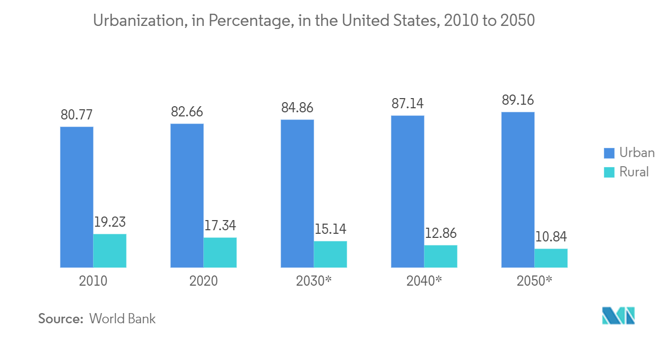
Earth Observation Satellite is Playing an Important Role in Urban Development
- Urban development and cultural heritage are expected to dominate the market share. Earth observation satellites have emerged as indispensable tools for urban development, playing a vital role in shaping and managing cities in the United States. These high-tech satellites provide a unique vantage point from space, offering valuable data and insights that enable informed decision-making, sustainable planning, and efficient resource management.
- Earth observation satellites have significantly influenced infrastructure development in the US by facilitating precise mapping, monitoring, and analysis. Satellites equipped with advanced imaging sensors capture high-resolution images of urban areas, enabling accurate mapping of existing infrastructure and identification of potential development sites.
- This data helps urban planners, and policymakers make informed decisions regarding land use, transportation networks, and utility infrastructure placement. Additionally, satellite data aids in monitoring the condition of critical infrastructure, such as bridges and roads, by detecting signs of deterioration and enabling timely maintenance.
- Urban transportation planning is another area where Earth observation satellites have proved invaluable. Satellites provide real-time traffic data, including congestion levels, traffic flows, and travel patterns, allowing transportation authorities to optimize traffic management strategies and enhance mobility.
- Satellite data also aids in planning and developing public transportation systems, helping identify high-demand routes and areas needing improved connectivity. Moreover, satellites enable the monitoring of transportation infrastructure projects, facilitating progress tracking and ensuring adherence to timelines and regulations.
- Moreover, Earth observation satellites are instrumental in monitoring and managing the environmental aspects of urban areas. Satellites equipped with specialized sensors capture data on air quality, land cover changes, vegetation health, and water resources, among other parameters.
- This information assists environmental agencies and city planners in assessing the impact of urbanization on the environment, identifying areas prone to pollution, and implementing measures to mitigate environmental degradation. By monitoring urban heat islands, satellites also contribute to developing strategies for heat stress reduction and energy efficiency in cities.