Market Trends of United States Geospatial Analytics Industry
Network Analysis is Expected to Hold Significant Share of the Market
- Network Analysis enables end-users to incorporate location-based information into their decision-making process. In several cases, firms must consider all possible cases for making effective decisions regarding cost and resources. GIS is widely used for studying real-world problems related to operations research and flow-related issues, such as transportation research. Some significant applications of network analysis in operations research include selecting the best route, shortest path analysis, optimal allocation of finite resources, network partitioning, selection of closest maintenance facility, and location-allocation, among others.
- The use of network analysis has gained prominence in today's cities, which are becoming increasingly congested. For instance, in the case of any emergency response system (ERS), the best route or shortest path analysis data using spatial data directly improves the fire emergency response, police station emergency response, healthcare emergency response system, etc. Google Maps extensively uses spatial data to provide multiple routes, the best routes, and real-time analysis to re-route in case the user cannot follow the suggested path.
- The players in the market are collaborating to provide better services to its customer and expand their market presence. For example, Mapbox, one of the prominent mapping and location cloud platforms for developers, and Ookla, the renowned company that developed Speedtest and Downdetector, have joined forces worldwide to develop ground-breaking network-aware mapping solutions. Technologies that offer significant new value to each company's customers will be developed together. Because of their combined capabilities and expertise, Ookla and Mapbox are uniquely positioned to transform connectivity-aware mapping features and geospatial network analysis.
- Further, in April 2023, SpaceKnow and Chia Network, Inc. have announced a partnership to unlock actionable space intelligence and data for the benefit of sustainability initiatives, beginning with the AgroTech sector. SpaceKnow and Chia will create and maintain a geospatial database to track land enrollment in sustainability programs. Secured with Chia's Virtual Private Blockchain, the database will be trusted and spatially accessible to authorized market participants. By establishing auditable procedures that guarantee accuracy and foster market trust, the technology solution seeks to address industry issues. This geospatial database will inform project developers and standards, monitor participant field activity, and help leverage data to encourage program participation and engagement.
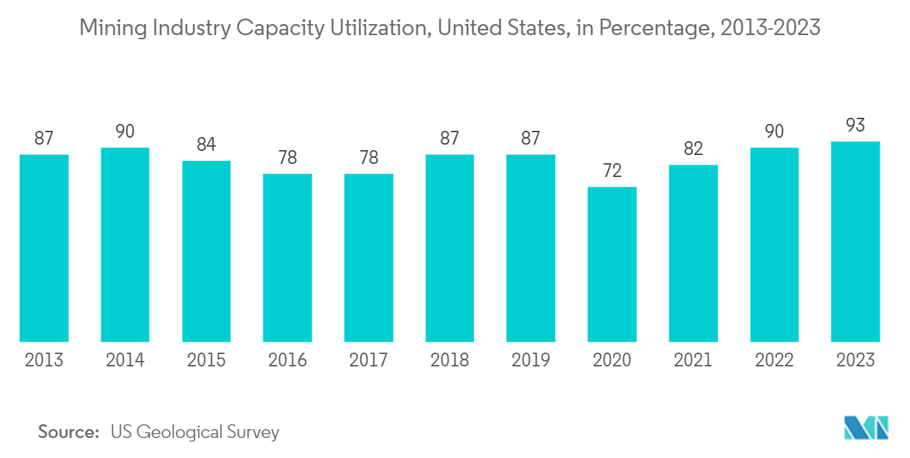
- Geospatial network analysis is crucial in the mining industry to identify essential habitat patches and plan and manage mining operations. With the help of geographic information systems (GIS), spatial databases, and specialized software tools, mining companies can perform spatial analyses, create linear networks of interconnected features, and perform detailed spatial analyses on them. Such tools help identify ecological sources based on morphology, create vector-based network analysis to optimize transportation, and use spatial data mining to solve complex problems. According to US Geological Survey, In 2023, the capacity utilization of the United States' mining industry stood at an estimated 93%. Such huge in mining capacity would drive the studied market
Understand The Key Trends Shaping This Market
Download PDF
Defense and Intelligence is Expected to Hold Significant Share of the Market
- Geospatial analytics plays a significant role in making decisions about national security involving geography. It is essential to understand the geographical data to assess potential terrorist targets and determine the place of a strike on the battlefield. Data analysis can also decide where to locate a new building with minimal environmental impact. For instance, the US army uses geospatial analytic tools to boost its terrain awareness. Under the US government administration, increased spending on US defense has led to a growing demand for geospatial analytics. Mounting geopolitical tensions in Asia-Pacific, Iran, and the United States, are also responsible for the increased demand.
- There are regulations in the United States regarding geospatial analytics and defense. The National Geospatial-Intelligence Agency (NGA) is a combat support agency within the United States Department of Defense that collects, analyzes, and distributes geospatial intelligence (GEOINT) to support national security. The agency assists in security planning for major events and has a mission in GEOINT. The regulations related to geospatial analytics and defense are governed by the Export Administration Regulations (EAR) under the U.S. Department of Commerce. These regulations control the export of "dual-use" technologies (i.e., those with civil and military applications), including geospatial software and data.
- Further, one of the key technologies used in the network defense of the United States is EINSTEIN, which is an intrusion detection system operated by the Cybersecurity and Infrastructure Security Agency (CISA). EINSTEIN provides real-time network security and threat indicators by identifying and blocking unauthorized traffic before it enters a government network. Additionally, Palantir Gotham, a big data analytics tool, is used by counter-terrorism analysts at offices in the United States Intelligence Community (USIC) and Department of Defense (DoD). Lastly, Cisco Secure Network Analytics is a tool that provides network detection and response to help defend against cyber threats.
- Geovisualization enables defense industry players accelerate decision-making, workflows, policies, and engagement with the use of a Geographic Information System (GIS). GIS is used to support various defense missions, including intelligence, operations, and readiness, by integrating those disciplines into a common environment. GIS is also used for military logistics, such as moving supplies, equipment, and troops where they are needed at the right time. It can also be used for defence site management to manage bases and detachments across all levels of command. Some examples of GIS applications in defense include the use of cloud-based GIS, AI, big data, and other remote sensing technologies.
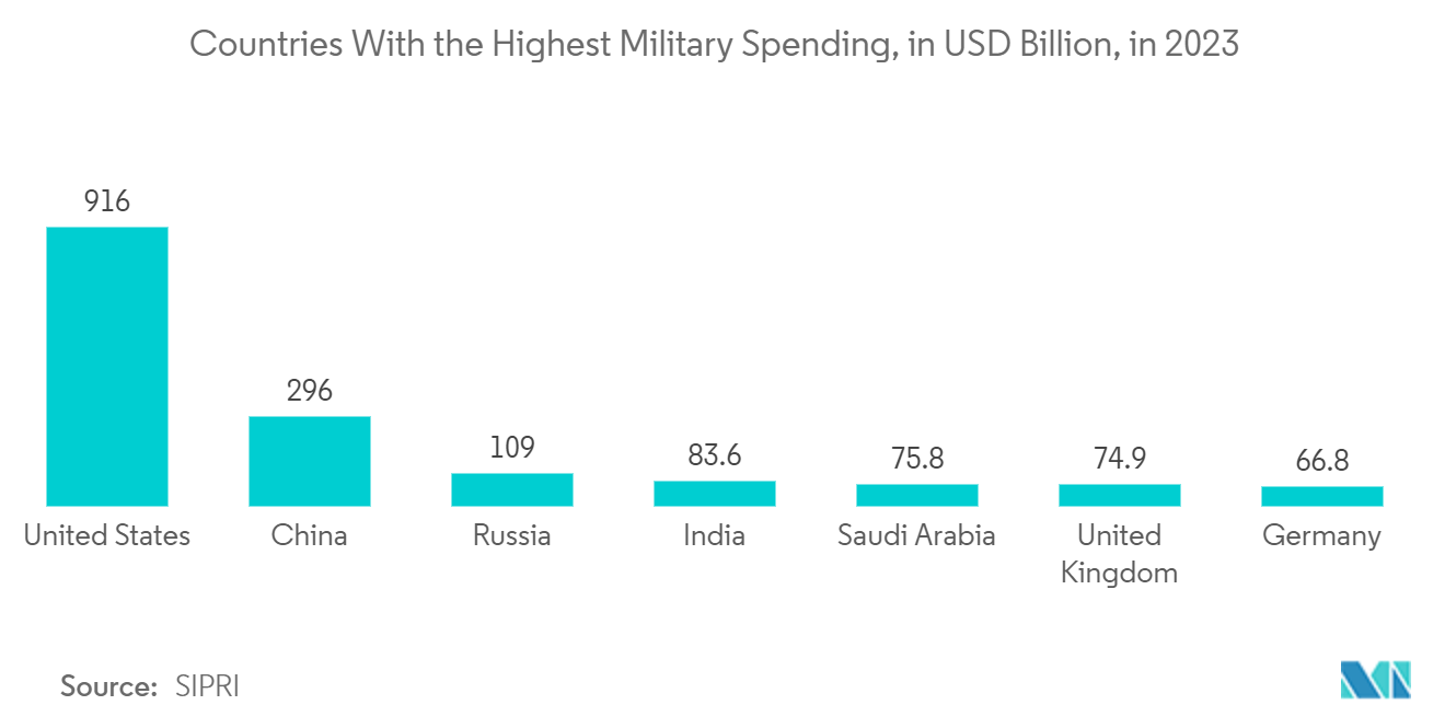
- According to SIPRI, In 2023, the United States topped the list of countries with the highest military expenditure, allocating 916 billion USD for defense purposes. This made up more than 40 percent of the global military expenditure in that year, totaling 2.4 trillion USD.