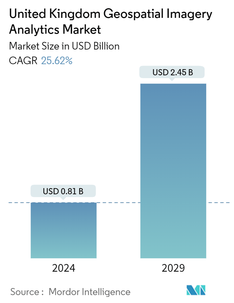
Market Size of United Kingdom Geospatial Imagery Analytics Industry
| Study Period | 2019 - 2029 |
| Base Year For Estimation | 2023 |
| Market Size (2024) | USD 0.81 Billion |
| Market Size (2029) | USD 2.45 Billion |
| CAGR (2024 - 2029) | 25.62 % |
| Market Concentration | Medium |
Major Players
*Disclaimer: Major Players sorted in no particular order |
United Kingdom Geospatial Imagery Analytics Market Analysis
The United Kingdom Geospatial Imagery Analytics Market size is estimated at USD 0.81 billion in 2024, and is expected to reach USD 2.45 billion by 2029, growing at a CAGR of 25.62% during the forecast period (2024-2029).
- The demand for geospatial analysis used for data capture to understand weather modeling, population forecasting, and sales trends by visualization of spatial data is fueling the commercialization of geospatial imagery analytics, supporting the market growth in the United Kingdom.
- The application of spatial resolution sensing and imagery data analytics in developing the country's agriculture sector and other end-user industries by supporting its Environmental Land Management scheme is fueling the growth of the market. For instance, in September 2023, Earth-i, a UK-based geospatial intelligence company, used Earth observation data to provide insights derived from geospatial data that deliver decision advantages for businesses, governments, and other organizations. It was awarded a significant multi-year contract to provide environmental monitoring through Planet Labs' fleet of earth imaging satellites, showing the demand for geospatial imagery analytics solutions in the country.
- Geospatial data is increasingly used to help planners and developers identify social infrastructure, facilities, and community spaces in the country's city planning. For instance, in November 2023, IBM announced that it planned to apply its geospatial AI technologies, including IBM's geospatial foundation model developed in collaboration with NASA, to climate efforts, including climate resiliency in the United Kingdom. This shows the increasing importance of geospatial imagery analytics in urban planning in the country, supporting future market growth.
- The data privacy breaching risks related to the geospatial data and their impact on national security in the United Kingdom are creating a significant market restraint for adopting the geospatial imagery analytics market. Large-scale organizations, including companies' defense and critical infrastructure businesses, have high requirements for geospatial data. However, the concern for data security and the associated risk of geo-data hacking is in line with the growth of adverse geopolitical scenarios and the increasing landscape of cyber attacks, restricting the market growth during the forecast period.
United Kingdom Geospatial Imagery Analytics Industry Segmentation
Geospatial imagery analytics is a comprehensive solution system that provides imagery analytics from data collected through satellite images, including video and image data, of the earth for various applications across the end-user segments, including business intelligence, urban planning, and climate control solutions.
The study tracks the key market parameters, underlying growth influencers, and major vendors operating in the market, which supports the market estimations and growth rates over the forecast period. The study also tracks the revenue accrued through the sale of grown geospatial imagery analytics services used in various end-user industries across geography. In addition, the study provides the geospatial imagery analytics market trends, along with crucial vendor profiles. The study further analyses the overall impact of COVID-19 on the ecosystem.
The UK geospatial imagery analytics market is segmented by type (imagery analytics and video analytics), deployment mode (on-premise and cloud), organization size (SMEs and large enterprises), and verticals (insurance, agriculture, defense and security, environmental monitoring, engineering and construction, and government). The market sizes and forecasts are provided in terms of value (USD) for all the above segments.
| By Type | |
| Imagery Analytics | |
| Video Analytics |
| By Deployment Mode | |
| On-premise | |
| Cloud |
| By Organization Size | |
| SMEs | |
| Large Enterprises |
| By Verticals | |
| Insurance | |
| Agriculture | |
| Defense and Security | |
| Environmental Monitoring | |
| Engineering and Construction | |
| Government | |
| Others |
United Kingdom Geospatial Imagery Analytics Market Size Summary
The United Kingdom geospatial imagery analytics market is experiencing significant growth, driven by the increasing demand for data capture and analysis in various sectors such as urban planning, environmental monitoring, and agriculture. The market is supported by advancements in spatial resolution sensing and imagery data analytics, which are being utilized to enhance urban development, support environmental land management schemes, and aid in climate resilience efforts. The application of geospatial analytics in city planning and infrastructure development is becoming increasingly important, as evidenced by collaborations between technology companies and governmental organizations to leverage geospatial data for sustainable urban development. However, concerns regarding data privacy and security, particularly in relation to national security, pose challenges to market expansion.
The market is characterized by a moderate level of fragmentation, with numerous local and multinational solution providers actively investing in portfolio expansions and strategic partnerships to enhance their market presence. The UK government's initiatives, such as the Geospatial Strategy 2030 and collaborations with organizations like the Alan Turing Institute, aim to strengthen the country's position in geospatial innovation by maximizing the value of location data through AI and satellite imaging. Additionally, the rising awareness of environmental monitoring and the need for compliance with environmental regulations are driving the demand for geospatial imagery analytics solutions. These factors, combined with the increasing availability of earth imagery data, are expected to fuel market growth in the coming years.
United Kingdom Geospatial Imagery Analytics Market Size - Table of Contents
-
1. MARKET INSIGHTS
-
1.1 Market Overview
-
1.2 Industry Attractiveness - Porter's Five Forces Analysis
-
1.2.1 Bargaining Power of Buyers
-
1.2.2 Bargaining Power of Suppliers
-
1.2.3 Threat of New Entrants
-
1.2.4 Threat of Substitutes
-
1.2.5 Intensity of Competitive Rivalry
-
-
1.3 Industry Value Chain Analysis
-
1.4 Assessment of the Impact of COVID-19 on the Market
-
-
2. MARKET SEGMENTATION
-
2.1 By Type
-
2.1.1 Imagery Analytics
-
2.1.2 Video Analytics
-
-
2.2 By Deployment Mode
-
2.2.1 On-premise
-
2.2.2 Cloud
-
-
2.3 By Organization Size
-
2.3.1 SMEs
-
2.3.2 Large Enterprises
-
-
2.4 By Verticals
-
2.4.1 Insurance
-
2.4.2 Agriculture
-
2.4.3 Defense and Security
-
2.4.4 Environmental Monitoring
-
2.4.5 Engineering and Construction
-
2.4.6 Government
-
2.4.7 Others
-
-
United Kingdom Geospatial Imagery Analytics Market Size FAQs
How big is the United Kingdom Geospatial Imagery Analytics Market?
The United Kingdom Geospatial Imagery Analytics Market size is expected to reach USD 0.81 billion in 2024 and grow at a CAGR of 25.62% to reach USD 2.45 billion by 2029.
What is the current United Kingdom Geospatial Imagery Analytics Market size?
In 2024, the United Kingdom Geospatial Imagery Analytics Market size is expected to reach USD 0.81 billion.
