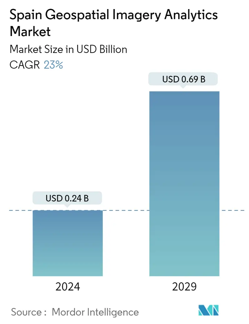
Market Size of Spain Geospatial Imagery Analytics Industry
| Study Period | 2019-2029 |
| Base Year For Estimation | 2023 |
| Market Size (2024) | USD 0.24 Billion |
| Market Size (2029) | USD 0.69 Billion |
| CAGR (2024 - 2029) | 23.00 % |
| Market Concentration | Medium |
Major Players
*Disclaimer: Major Players sorted in no particular order |
Spain Geospatial Imagery Analytics Market Analysis
The Spain Geospatial Imagery Analytics Market size is estimated at USD 0.24 billion in 2024, and is expected to reach USD 0.69 billion by 2029, growing at a CAGR of 23% during the forecast period (2024-2029).
Geospatial imagery analysis refers to a broad range of activities that emphasize applying various techniques to data comprising geographical or space-related characteristics. Some of the key factors driving the growth of the geospatial imagery analytics market include the increasing technological advancements in the field of GIS technology, recent trends in integration and convergence of geospatial technologies, the advent of new business models aimed at leveraging the demand for geospatial information, and increased application of geospatial analytics in city and town planning.
- The analysis of satellite or aerial photographs to generate significant information about the Earth's surface is done by geospatial imaging analytics. This technology is critical in many parts of mining operations, resulting in enhanced efficiency and safety. For instance, it allows mining companies to precisely assess mining conditions by offering a whole perspective of the location, which includes topography, terrain, vegetation cover, and infrastructure. Companies can improve safety and reduce accidents by analyzing this data, identifying possible dangers, and taking proactive efforts to mitigate them.
- Geospatial technology can provide extensive insights into a city's physical environment, infrastructure, and assets, allowing for more effective planning and decision-making. Higher frequencies, which are necessary for 5G networks, have a limited range and are prone to interference from various things. This data may be utilized to optimize the location of 5G infrastructure, resulting in higher network coverage and fewer signal disturbances. Several governments seeking to attract foreign direct investment have prioritized the development of 5G technology and infrastructure. Geospatial technology is critical in advancing these efforts, notably in developing smart cities.
- In March 2023, Esri announced a web-based mapping application built on the ArcGIS API for JavaScript for considering and analyzing global land-cover changes. Sentinel-2 Land Cover Explorer, the app, delivers Esri maps, image services, spatial analysis tools, and ESA Sentinel-2 imagery at 10m resolution. All these elements are combined and offered in a browser-based application that can be without additional software or login credentials.
- On the contrary, the legal and regulatory issues surrounding the usage of geospatial imaging analytics technologies are difficulties that stem from a variety of issues, including regional variations, location privacy concerns, intellectual property rights, data licensing, and geographical data storage. One of the key limits is the regional variation in data collection techniques. Geospatial imaging analytics is strongly reliant on current and reliable data, such as satellite images and aerial pictures. Access to such data, however, might be limited in particular locations or nations, making it difficult for geospatial technology suppliers to collect complete and consistent data for analysis.
- Demand for geospatial analytics applications, such as those used in tourism and transportation, decreased due to COVID-19. The production facilities were also closed, which made it more challenging to supply and regulate electrical components. However, the pandemic increased the demand for public health applications, emergency response applications, and environmental monitoring applications, which in turn are used to track the spread of COVID-19 and identify areas at risk.
Spain Geospatial Imagery Analytics Industry Segmentation
Geospatial imagery analytics utilizes data collected from satellite images. The geo-referenced images are then delivered as raster and vector images. Raster images are individual pixels of color, also known as bitmaps. Vector images are graphics comprised of mathematical formulas and can be infinitely scaled. The spain geospatial imagery analytics market is segmented by type,by deploymnet mode, by organization size and end user. By type, the market is segmented into imagery analytics and video analytics. By deploymenyt mode the market is segmented into on-premise and cloud. By organization size the market is segmented into SMEs and large enterprises. By verticals the market is segmented into insurance, agriculture, defense and security, environmental monitoring, engineering and construction, government and other verticals. The market sizes and forecasts are provided in terms of value in USD for all the above segments.
| By Type | |
| Imagery Analytics | |
| Video Analytics |
| By Deployment Mode | |
| On Premise | |
| Cloud |
| By Organization Size | |
| SMEs | |
| Large Enterprises |
| By Vericals | |
| Insurance | |
| Agriculture | |
| Defense and Security | |
| Environmental Monitoring | |
| Engineeting & Construction | |
| Government | |
| Others |
Spain Geospatial Imagery Analytics Market Size Summary
The Spain Geospatial Imagery Analytics Market is poised for significant growth, driven by advancements in GIS technology and the integration of geospatial technologies across various sectors. This market encompasses a wide range of activities that utilize geographical data to derive insights, playing a crucial role in urban planning, mining operations, and infrastructure development. The increasing application of geospatial analytics in optimizing 5G infrastructure and developing smart cities further propels market expansion. Despite challenges such as legal and regulatory issues, regional data access limitations, and the impact of COVID-19 on certain applications, the market is expected to thrive due to the rising demand for public health and environmental monitoring solutions.
The market landscape is characterized by the presence of key players like Google LLC, Microsoft Corporation, and Oracle Corporation, who are actively engaging in strategic partnerships and product innovations to enhance their market presence. The adoption of cloud-based solutions, particularly SaaS platforms, is gaining traction due to their cost-effectiveness, scalability, and ease of use compared to traditional on-premise systems. However, concerns regarding cloud security may hinder growth. Additionally, significant investments in defense and space exploration by the Spanish government, along with the development of advanced satellite imaging technologies, are expected to drive demand for geospatial imagery analytics. These developments underscore the market's potential as a critical tool for national security, infrastructure monitoring, and smart city initiatives.
Spain Geospatial Imagery Analytics Market Size - Table of Contents
-
1. MARKET INSIGHTS
-
1.1 Market Overview
-
1.2 Industry Attractiveness - Porter's Five Forces Analysis
-
1.2.1 Bargaining Power of Buyers
-
1.2.2 Bargaining Power of Suppliers
-
1.2.3 Threat of New Entrants
-
1.2.4 Threat of Substitutes
-
1.2.5 Intensity of Competitive Rivalry
-
-
1.3 Industry Value Chain Analysis
-
1.4 Assessment of the Impact of COVID-19 on the Market
-
-
2. MARKET SEGMENTATION
-
2.1 By Type
-
2.1.1 Imagery Analytics
-
2.1.2 Video Analytics
-
-
2.2 By Deployment Mode
-
2.2.1 On Premise
-
2.2.2 Cloud
-
-
2.3 By Organization Size
-
2.3.1 SMEs
-
2.3.2 Large Enterprises
-
-
2.4 By Vericals
-
2.4.1 Insurance
-
2.4.2 Agriculture
-
2.4.3 Defense and Security
-
2.4.4 Environmental Monitoring
-
2.4.5 Engineeting & Construction
-
2.4.6 Government
-
2.4.7 Others
-
-
Spain Geospatial Imagery Analytics Market Size FAQs
How big is the Spain Geospatial Imagery Analytics Market?
The Spain Geospatial Imagery Analytics Market size is expected to reach USD 0.24 billion in 2024 and grow at a CAGR of 23% to reach USD 0.69 billion by 2029.
What is the current Spain Geospatial Imagery Analytics Market size?
In 2024, the Spain Geospatial Imagery Analytics Market size is expected to reach USD 0.24 billion.
