Market Size of Saudi Arabia Geospatial Analytics Industry
| Study Period | 2019 - 2029 |
| Base Year For Estimation | 2023 |
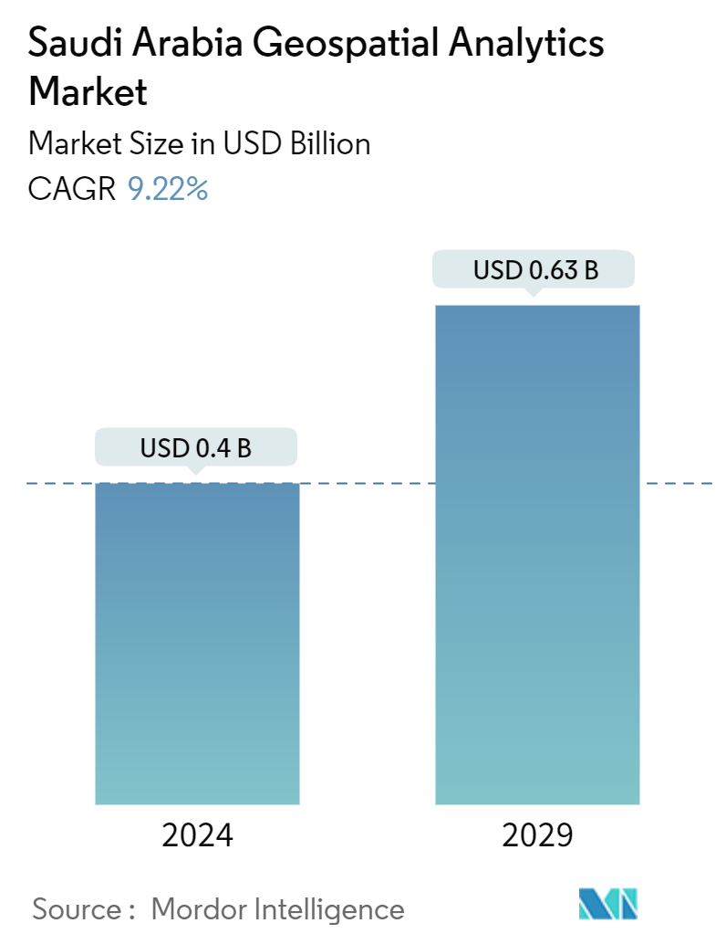
| Market Size (2024) | USD 0.4 Billion |
| Market Size (2029) | USD 0.63 Billion |
| CAGR (2024 - 2029) | 9.22 % |
| Market Concentration | Medium |
Major Players*Disclaimer: Major Players sorted in no particular order |
Saudi Arabia Geospatial Analytics Market Analysis
The Saudi Arabia Geospatial Analytics Market size is estimated at USD 0.4 billion in 2024, and is expected to reach USD 0.63 billion by 2029, growing at a CAGR of 9.22% during the forecast period (2024-2029).
Geospatial analysis refers to a broad range of activities that emphasize applying various techniques to data comprising geographical or space-related characteristics. Some of the key factors driving the development of the geospatial analytics market include the increasing use of GPS devices, technological advances in the field of GIS technology, recent trends in integration and convergence of geospatial technologies, the advent of new corporation models aimed at leveraging the demand for geospatial information, and increased application of geospatial analytics in city and town planning.
- Network analysis has gained prominence in today's cities, which are becoming increasingly congested. For instance, in the case of any emergency response system (ERS), the best route or shortest path analysis data using spatial data directly improves the fire emergency response, police station emergency response, healthcare emergency response system, etc. Google Maps extensively uses spatial data to provide multiple routes, the best routes, and real-time analysis to re-route in case the user cannot follow the suggested path.
- Furthermore, network analysis is significant for utility companies operating in cities with complex network asset management problems. It helps companies efficiently design and model complex network infrastructures for supplying electrical, telecommunications, gas, and water to consumers using spatial data.
- Saudi Arabia is keen to explore new opportunities and ways to revitalize the quality of its major cities. For instance, the Ministry of Municipal and Rural Affairs (MOMRA) launched the nation's first Smart Cities program, an ambitious initiative by the government to drive smart transformation in Saudi cities to enter the digital age. In the program's initial phase, 17 selected cities comprising about 72 percent of the country's population were selected for carrying out smart urban projects. This effort is supplemented by a USD 500 billion investment that focuses on modernizing the infrastructure of the existing 285 municipalities across Saudi Arabia.
- In November 2022, Saudi Arabia kept pace with the rest of the world by introducing advanced research centers in geographical sciences, achieving a breakthrough in geospatial technologies, and meeting the labor market requirements of specialists per the Kingdom's Vision 2030. In addition, they are building bridges of cooperation with public and private institutions related to the same field as the world celebrates Geographic Information Systems (GIS) Day to enhance awareness of GIS technology and discuss the obstacles related to its applications. The Saudi Geological Survey (SGS) is one of the first leading government agencies in the Kingdom mandated with using spatial information systems management for its various scientific and technical activities.
- High costs and operational concerns, such as the limited presence of open standards and interoperability mechanisms and integration issues between enterprise risk management (ERM) and GIS systems, hinder the geospatial analytics market's adoption rate. Although the overall costs of geospatial analysis solutions have decreased drastically since the turn of the decade, owing to the greater availability of open-source tools and plunging hardware costs, it remains a major concern for small and medium-scale companies. Generic location-based data is readily available over the Internet; however, it offers limited demographic insights and is not completely useful for making strategic decisions.
Saudi Arabia Geospatial Analytics Industry Segmentation
Geospatial analytics is the process of acquiring, manipulating, and displaying imagery and data from the geographic information system (GIS), such as satellite photos and GPS data. The specific identifiers of a street address and a zip code are used in geospatial data analytics. They are used to create geographic models and data visualizations for more accurate trends modeling and forecasting.
The Saudi Arabia geospatial analytics market is segmented by type (surface analysis, network analysis, and geovisualization), by end-user vertical (agriculture, utility and communication, defense and intelligence, government, mining and natural resources, automotive and transportation, healthcare, real estate and construction, and other end-user verticals).
The market sizes and forecasts are provided in terms of value (USD) for all the above segments.
| By Type | |
| Surface Analysis | |
| Network Analysis | |
| Geovisualization |
| By End-User Vertical | |
| Agriculture | |
| Utility and Communication | |
| Defense and Intelligence | |
| Government | |
| Mining and Natural Resources | |
| Automotive and Transportation | |
| Healthcare | |
| Real Estate and Construction | |
| Other End-User Verticals |
Saudi Arabia Geospatial Analytics Market Size Summary
The geospatial analytics market in Saudi Arabia is poised for significant growth, driven by advancements in GIS technology and the increasing integration of geospatial technologies across various sectors. This market is experiencing a surge in demand due to the rising use of GPS devices and the application of geospatial analytics in urban planning and smart city initiatives. The Saudi government's Vision 2030 and its ambitious Smart Cities program are pivotal in this growth, as they aim to modernize urban infrastructure and enhance the quality of life in major cities. The introduction of advanced research centers and collaboration with public and private institutions further underscores the Kingdom's commitment to leveraging geospatial technologies for economic and social development.
The market landscape is moderately consolidated, with key players like Microsoft, Autodesk, and Esri actively investing in strategic partnerships and product innovations to capture market share. The integration of geospatial technology with building information modeling (BIM) is transforming the construction industry, promoting efficiency and cost-effectiveness in urban infrastructure projects. As Saudi Arabia continues to invest in megaprojects and infrastructure development, the demand for geospatial analytics is expected to rise, offering substantial opportunities for market players. Despite challenges such as high costs and interoperability issues, the availability of open-source tools and decreasing hardware costs are facilitating broader adoption of geospatial analytics solutions across the region.
Saudi Arabia Geospatial Analytics Market Size - Table of Contents
-
1. MARKET INSIGHTS
-
1.1 Market Overview
-
1.2 Industry Attractiveness - Porter's Five Forces Analysis
-
1.2.1 Bargaining Power of Buyers
-
1.2.2 Bargaining Power of Suppliers
-
1.2.3 Threat of New Entrants
-
1.2.4 Threat of Substitutes
-
1.2.5 Intensity of Competitive Rivalry
-
-
1.3 Industry Value Chain Analysis
-
1.4 Assessment of the Impact of COVID-19 on the Market
-
-
2. MARKET SEGMENTATION
-
2.1 By Type
-
2.1.1 Surface Analysis
-
2.1.2 Network Analysis
-
2.1.3 Geovisualization
-
-
2.2 By End-User Vertical
-
2.2.1 Agriculture
-
2.2.2 Utility and Communication
-
2.2.3 Defense and Intelligence
-
2.2.4 Government
-
2.2.5 Mining and Natural Resources
-
2.2.6 Automotive and Transportation
-
2.2.7 Healthcare
-
2.2.8 Real Estate and Construction
-
2.2.9 Other End-User Verticals
-
-
Saudi Arabia Geospatial Analytics Market Size FAQs
How big is the Saudi Arabia Geospatial Analytics Market?
The Saudi Arabia Geospatial Analytics Market size is expected to reach USD 0.4 billion in 2024 and grow at a CAGR of 9.22% to reach USD 0.63 billion by 2029.
What is the current Saudi Arabia Geospatial Analytics Market size?
In 2024, the Saudi Arabia Geospatial Analytics Market size is expected to reach USD 0.4 billion.
