
Saudi Arabia Geospatial Analytics Market Size and Share
Market Overview
| Study Period | 2020 - 2031 |
|---|---|
| Forecast Data Period | 2026 - 2031 |
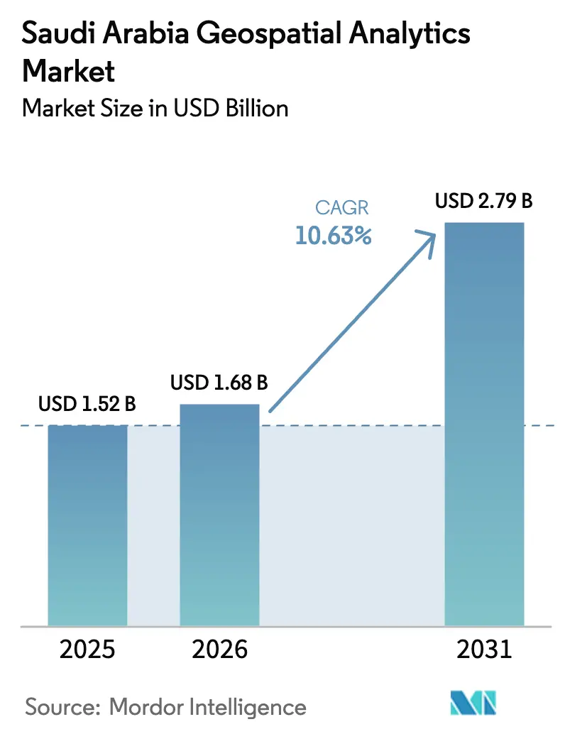
| Base Year Market Size (2025) | USD 1.52 Billion |
| Market Size (2026) | USD 1.68 Billion |
| Market Size (2031) | USD 2.79 Billion |
| Growth Rate (2026 - 2031) | 10.63 % |
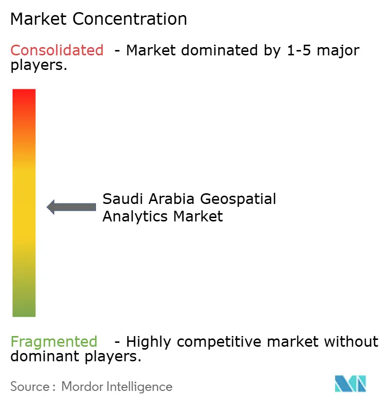
| Market Concentration | Medium |
Major Players *Disclaimer: Major Players sorted in no particular order Image © Mordor Intelligence. Reuse requires attribution under CC BY 4.0. | |
Saudi Arabia Geospatial Analytics Market Analysis by Mordor Intelligence
The Saudi Arabia geospatial analytics market size in 2026 is estimated at USD 1.68 billion, growing from 2025 value of USD 1.52 billion with 2031 projections showing USD 2.79 billion, growing at 10.63% CAGR over 2026-2031. Momentum stems from Vision 2030 smart-city mandates, public-sector digitization, and a nationwide shift toward cloud-first spatial infrastructures. The Saudi Arabia geospatial analytics market continues to benefit from hyperscale data-center roll-outs that lower the total cost of ownership and from abundant Earth-observation data that unlock real-time monitoring use cases. Rising commercial demand, especially in retail and logistics, signals diversification beyond governmental projects. Moderate market concentration encourages technology partnerships, while the Personal Data Protection Law sets a strict compliance baseline that shapes deployment choices.[1]
Key Report Takeaways
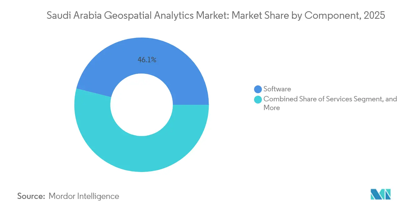
- By component, software led with 46.12% revenue share of the Saudi Arabia geospatial analytics market in 2025; data and content are projected to expand at a 11.78% CAGR through 2031.
- By type, surface analysis accounted for 45.15% of the Saudi Arabia geospatial analytics market share in 2025, while spatial data mining and predictive modeling are advancing at a 12.18% CAGR through 2031.
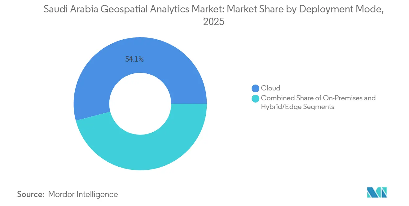
- By deployment mode, cloud captured 54.10% of the 2025 revenue of the Saudi Arabia geospatial analytics market and is growing at an 11.55% CAGR through 2031.
- By data source, satellite and aerial imagery commanded 44.62% of demand in 2025 of the Saudi Arabia geospatial analytics market; mobile and social-media geo-data is set to rise at a 12.09% CAGR.
- By end-user vertical, government and smart-city authorities held 27.84% of the 2025 spending of the Saudi Arabia geospatial analytics market, whereas retail and location-based services are poised for a 12.52% CAGR.
- By region, the central region dominated with a 42.96% share of the Saudi Arabia geospatial analytics market in 2025, while the eastern region is projected to register the fastest 11.78% CAGR.
Note: Market size and forecast figures in this report are generated using Mordor Intelligence’s proprietary estimation framework, updated with the latest available data and insights as of 2026.
Competitive positioning in Saudi arabia includes both locally based firms and those operating across multiple regions. The market landscape in the global geospatial analytics industry research shows how these players are arranged internationally.
Market Trends and Insights
Drivers Impact Analysis of Saudi Arabia Geospatial Analytics Market*
| Driver | (~) % Impact on CAGR Forecast | Geographic Relevance | Impact Timeline |
|---|---|---|---|
| Vision 2030 smart-city mandates | +2.8% | Central and Western | Long term (≥ 4 years) |
| Rapid cloud build-out | +2.1% | Central and Eastern | Medium term (2-4 years) |
| GIS adoption in megaprojects | +1.9% | Western and Central | Long term (≥ 4 years) |
| High-resolution EO and SAR access | +1.4% | National | Medium term (2-4 years) |
| National Geospatial Platform APIs | +1.2% | Central | Short term (≤ 2 years) |
| NSG–Esri GeoAI alliance | +0.9% | Central expanding national | Medium term (2-4 years) |
| Source: Mordor Intelligence | |||
Vision 2030 Smart-City Mandates Accelerating Demand for Location Intelligence
Vision 2030 allocates SAR 1.285 trillion in 2025 spending to development programs, driving large-scale adoption of geospatial analytics across NEOM, the Red Sea Project, and Qiddiya. NEOM’s linear urban design depends on continuous spatial modeling for infrastructure routing, environmental monitoring, and visitor services.[2] Ninety-seven percent of government services are now digitized, generating datasets that require location-based analysis. Utilities integrate geospatial analytics to manage smart grids, while the Saudi Green Initiative’s pledge to plant 10 billion trees by 2030 relies on spatial suitability modeling. These programs collectively embed geospatial thinking into national development, firmly anchoring the Saudi Arabian geospatial analytics market.
Rapid Cloud and Hyperscale Data-Center Build-Out Lowering TCO
Cloud providers have invested USD 2.5 billion in local data centers, establishing sovereign infrastructure that removes cross-border data-transfer bottlenecks.[3] The 2023 Cloud Computing Special Economic Zone offers tax incentives and localization clarity, encouraging organizations to migrate spatial workloads. Elastic compute capacity enables resource-intensive processes such as digital twins and AI-driven image analytics. Neo Space Group’s UP42 acquisition exemplifies how local firms leverage cloud platforms to scale on-demand analytics. Lower capital expenditure accelerates cloud adoption, reinforcing the leadership of cloud within the Saudi Arabian geospatial analytics market.
Widespread GIS Adoption in Utilities and Infrastructure Megaprojects
Utilities responsible for a USD 1.5 trillion construction pipeline use geospatial tools for asset siting, predictive maintenance, and route optimization. NEOM’s 100% renewable grid depends on spatial resource assessments; Saudi Aramco integrates geospatial analytics for pipeline integrity and environmental compliance. Water and Electricity Company projects employ location intelligence to shorten outage response times. Each deployment expands the installed base of spatial platforms, stimulating demand for services and high-resolution datasets across the Saudi Arabian geospatial analytics market.
Commercial Availability of High-Resolution EO Constellations and SAR Data
Local access to sub-meter imagery and SAR data improves coverage over dust-prone deserts and coastal areas. Ministries responsible for agriculture and environment now procure continuous monitoring datasets to support food security and land-rehabilitation programs. High revisit rates enable progress tracking for giga-projects, fueling the data-and-content segment’s double-digit growth trajectory.
Restraints Impact Analysis of Saudi Arabia Geospatial Analytics Market*
| Restraint | (~) % Impact on CAGR Forecast | Geographic Relevance | Impact Timeline |
|---|---|---|---|
| Up-front licensing and imagery costs for SMEs | -1.8% | Northern and Southern | Short term (≤ 2 years) |
| Geoprivacy and data-sovereignty constraints | -1.2% | National | Medium term (2-4 years) |
| GASGI permit cycles for UAV/LiDAR | -0.9% | National | Short term (≤ 2 years) |
| Scarcity of bilingual spatial-data scientists | -0.7% | Central and Eastern | Long term (≥ 4 years) |
| Source: Mordor Intelligence | |||
High Up-Front Licensing and Data-Acquisition Costs for SMEs
Enterprise GIS suites often require initial payments above USD 50,000, and premium satellite imagery packages add further expense. Cost burdens hinder smaller firms, especially in regions dominated by SMEs. SDAIA’s regulatory sandbox provides experimentation space, yet budget realities delay full-scale deployments. This capex hurdle slows broader ecosystem growth within the Saudi Arabia geospatial analytics market.
Geoprivacy and Data-Sovereignty Concerns
Personal Data Protection Law enforcement, since September 2024, imposes strict rules for geospatial datasets that can identify individuals. Cross-border transfers now need SDAIA contracts, and National Cybersecurity Authority controls add security overhead. International vendors must localize processing pipelines, extending project lead times and costs.
*Our forecasts treat driver/restraint impacts as directional, not additive. The impact forecasts reflect baseline growth, mix effects, and variable interactions.
Saudi Arabia Geospatial Analytics Market Segment Analysis
By Component:
Software Platforms Anchor Market GrowthThe Saudi Arabia geospatial analytics market size shows software solutions at a 46.12% share in 2025. Cloud-native GIS suites integrate seamlessly with national e-government backbones, allowing ministries to visualize assets and model growth scenarios. Vendors embed AI modules for automated feature extraction, aligning with the National Strategy for Data and AI. Data and content, growing at a 11.78% CAGR, benefit from expanded access to EO constellations and SAR feeds that address desert climate challenges.
Professional services flourish as agencies request customized dashboards and predictive models for megaproject oversight. Local providers such as Neo Space Group package imagery with analytics toolkits, reducing foreign-data dependency. Hardware and sensor demand remain steady, driven by IoT devices in smart grids and environmental monitoring stations. Together, these dynamics reinforce software leadership while showcasing the evolving component mix of the Saudi Arabia geospatial analytics market.

By Type:
Surface Analysis Leads, Predictive Modeling SurgesSurface analysis held 45.15% Saudi Arabia geospatial analytics market share in 2025, reflecting heavy use in terrain modelling for construction and renewable-energy siting. Civil works teams overlay topography with engineering plans to reduce earth-moving costs. Spatial data mining and predictive modeling register a 12.18% CAGR as agencies apply machine learning to traffic flows, climate forecasts, and public-health surveillance.
Network and location analysis support logistics corridors that link Gulf ports with inland hubs. Geovisualization tools enable immersive 3D city twins used by NEOM planners to engage stakeholders. Government funding for AI research accelerates algorithm development, ensuring predictive modeling will capture a larger slice of the Saudi Arabia geospatial analytics market size over the forecast horizon.
By Deployment Mode:
Cloud Extends Its LeadCloud captured 54.10% revenue in 2025 and is expanding at an 11.55% CAGR, making it the primary delivery model for the Saudi Arabia geospatial analytics market. Organizations deploy spatial workloads on Saudi-hosted instances of Azure, Google Cloud, and Oracle to meet localization mandates. Pay-as-you-go pricing lowers entry barriers and supports surge processing for remote-sensing imagery.
On-premises systems linger in defense and critical-infrastructure settings where air-gapped environments are mandatory. Hybrid and edge setups address real-time needs such as smart intersections that demand millisecond latency. As 5G coverage widens, edge nodes will process video analytics and LiDAR in situ, complementing rather than replacing centralized cloud pipelines.
By Data Source:
Satellites Dominate, Mobile Data Gains PaceSatellite and aerial imagery accounted for 44.62% of 2025 demand, underscoring reliance on overhead monitoring for gigaproject oversight. SAR sensors supply cloud-penetrating views essential for sandstorm-prone locales. The Saudi Arabia geospatial analytics market size linked to mobile and social-media geo-data is growing fastest at a 12.09% CAGR as anonymization frameworks permit retail and mobility analytics.
UAV-based LiDAR unlocks sub-centimeter mapping for heritage preservation and volumetric stockpile auditing, but GASGI permit timelines remain a bottleneck. Continuous feeds from IoT sensors in utilities, pipelines, and agriculture provide high-frequency updates that, when fused with satellite imagery, enable multi-scale decision workflows.
By End-User Vertical:
Government Stronghold Meets Retail UpswingGovernment and smart-city authorities generated 27.84% of 2025 spending, driven by Vision 2030 digital-service targets. Ministries depend on enterprise GIS to track infrastructure spend and environmental metrics. Retail and location-based services are projected to lead growth at a 12.52% CAGR as malls, quick-service restaurants, and e-commerce firms harness footfall analytics for site selection.
Utilities and energy enterprises employ geospatial analytics for grid optimization, while defense agencies demand high-security platforms. Agriculture programs use remote sensing to optimize irrigation in water-scarce zones, aligning with FAO-backed efficiency pilots. These diverse use cases broaden the Saudi Arabia geospatial analytics market beyond its public-sector foundation.
Geography Analysis
The central region, including Riyadh, held 42.96% 2025 share, cementing its status as the administrative and technological hub of the Saudi Arabia geospatial analytics market. The central region’s leadership in the Saudi Arabia geospatial analytics market derives from Riyadh’s concentration of ministries responsible for digital governance, procurement, and regulatory oversight. Budget allocations recorded in the 2025 fiscal plan earmark extensive capital for smart-city projects, stimulating continuous spatial-data procurement and platform roll-outs. Educational institutions in the capital add a pipeline of GIS graduates, partially easing the talent shortage.
The eastern region shows the highest 11.78% CAGR, propelled by energy-sector modernization and port-logistics upgrades. The eastern region grows rapidly on the back of Saudi Aramco’s digital oilfield initiatives, petrochemical facility upgrades, and port automation in Dammam and Jubail. These industries embed location intelligence to reduce downtime, manage pipelines, and ensure environmental compliance. Mining concessions mapped through the Ta’adeen Platform expand the Saudi Arabia geospatial analytics market size for mineral exploration and operations monitoring.
The western corridor benefits from giga-projects such as NEOM’s linear city, the Red Sea luxury tourism zone, and the entertainment city of Qiddiya. Each project requires multi-disciplinary spatial solutions covering environmental impact assessments, construction progress tracking, and visitor-flow optimization. Religious-tourism centers in Makkah and Madinah deploy crowd-management analytics to ensure pilgrim safety. Northern and southern provinces leverage precision farming and border-security applications, highlighting how diverse geography shapes demand patterns.
Mordor Intelligence tracks the geospatial analytics market across other major regions such as Africa and Middle East, with additional country-level coverage spanning Israel, Russia, Italy, Germany, France, Spain, and Nigeria, each reflecting localized structural drivers, restraints and more.
Regulatory Landscape
Geospatial data generation, survey, and imaging activities in Saudi Arabia are overseen by the General Authority for Survey and Geospatial Information (GEOSA), established under Council of Ministers Resolution No. 90 (2020). GEOSA issues and enforces National Geospatial Data Policies that cover data classification, licensing, pricing, sharing, and protection, and it runs licensing and permits for activities such as aerial photography, hydrographic marine surveying, and panoramic photography. These requirements can affect UAV, LiDAR, and field-survey project timelines.
Interoperability and quality requirements are set out through national geospatial standards coordinated with the Saudi Standards, Metrology and Quality Organization (SASO), aligned with ISO/TC 211 and the Open Geospatial Consortium (OGC). In parallel, the Personal Data Protection Law enforcement baseline (in force since September 2024) and related cybersecurity controls influence how location datasets are stored, processed, and transferred, which pushes vendors and users toward Saudi-hosted processing and tighter governance for data that can identify individuals.
Value Chain Analysis
The Saudi Arabia geospatial analytics value chain starts with data acquisition and aggregation, including satellite and aerial imagery, UAV/drone surveys (subject to GEOSA permitting), and IoT sensor streams from utilities and infrastructure. Upstream suppliers include Earth-observation data providers and local aggregators, while GEOSA supports public-sector data consolidation and access through mechanisms such as the National Geospatial Infrastructure Window and the broader Saudi Arabian National Geospatial Ecosystem (SANGE) framework that connects policies, standards, enabling technologies, and capacity building.
The midstream and downstream layers include geospatial platforms (enterprise GIS, cloud-native analytics, and GeoAI toolchains), systems integrators, and professional services that configure digital twins, sector dashboards, and predictive models for government, utilities, energy, and commercial users. Domestic capability is expanding through Neo Space Group (NSG), a Public Investment Fund (PIF) owned player that provides EO services and geospatial analytics and uses platform-based distribution (UP42) to package multi-source data and analytics. The chain concludes with operationalization by smart-city authorities and enterprises, where compliance, data residency, and bilingual enablement shape vendor selection and deployment architectures.
Competitive Landscape
The Saudi Arabia geospatial analytics market hosts a balanced mix of international platform providers and fast-emerging domestic firms. Esri’s long-standing government relationships anchor large-scale GIS deployments, while Hexagon and Trimble offer specialized survey and asset-management modules. Neo Space Group accelerates vertical integration by acquiring UP42 to secure local control over satellite imagery provisioning.[4]
Global cloud vendors cultivate regional presence to satisfy data-residency laws and deliver turnkey spatial-services stacks. The NSG–Esri GeoAI alliance trains algorithms on Arabic-language datasets, building localized feature catalogs that raise performance benchmarks. Start-ups leverage the National Geospatial Platform’s open APIs to offer sector-specific dashboards in retail analytics and logistics routing.
Competitive dynamics center on data-localization compliance, AI integration, and development of bilingual interfaces. Firms that bundle imagery, software, and domain consulting gain traction among agencies tasked with tight Vision 2030 deadlines. Moderate consolidation coexists with ample room for niche specialists, keeping the Saudi Arabia geospatial analytics market vibrant yet disciplined.
Saudi Arabia Geospatial Analytics Industry Leaders
-
Environmental Systems Research Institute, Inc.
-
Neo Space Group JSC
-
Saudi Company for Artificial Intelligence
-
TechButtons IT Solutions LLC
-
xMap Inc.
- *Disclaimer: Major Players sorted in no particular order
Saudi Arabia Geospatial Analytics Market Companies Covered in this Report
- Environmental Systems Research Institute, Inc.
- Neo Space Group JSC
- Saudi Company for Artificial Intelligence
- TechButtons IT Solutions LLC
- xMap Inc.
- Hexagon AB
- Trimble Inc.
- Bentley Systems Incorporated
- Autodesk Inc.
- Planet Labs PBC
- Maxar Technologies Inc.
- L3Harris Technologies Inc.
- Fugro N.V.
- RMSI Private Limited
- Spatial Arabia Company
- Geospatial Insight Limited
- Alteryx Inc.
- SAP SE
- General Electric Company
- Oracle Corporation
- Google LLC
- Trimble Solutions Middle East (Regional Subsidiary)
Read Analysis of Saudi Arabia Geospatial Analytics Companies
Market Opportunities and Future Outlook
White space in Saudi Arabia is concentrated on compliant, standards-based sharing and commercialization of national datasets and derived analytics products across sectors that have often relied on bespoke government procurement. GEOSA-operated control and compliance mechanisms, along with its sandbox environment for testing solutions such as mobile mapping, digital mapping, and smart navigation, provide a route for local firms and international vendors to validate offerings under Saudi requirements before scaling deployments.
Platformization of Earth-observation access is also creating space for differentiated data products and vertical solutions. NSG's acquisition of UP42, together with the build-out of a local Earth-observation digital platform, supports opportunities in analysis-ready imagery, elevation intelligence, and sector packages spanning agriculture monitoring, urban planning, real estate and infrastructure oversight, and disaster management workflows. With the Personal Data Protection Law enforcement baseline in place, vendors that provide Saudi-hosted processing, privacy-by-design workflows for mobile and location data, and OGC/ISO-aligned interoperability are better positioned to serve both national programs and growing commercial use cases in logistics and retail location intelligence.
Recent Industry Developments in Saudi Arabia Geospatial Analytics Market
- July 2026: Intermap Technologies partners with NSG UP42 to expand access to elevation intelligence in Saudi Arabia. The elevation data integration supports the national EO marketplace by enhancing terrain sensing capabilities. The collaboration matures the sovereign EO stack and expands high resolution terrain data services within the NSG UP42 platform.
- October 2025: NSG Geospatial Services launches NeoMaps, a national platform dedicated to Earth observation and geospatial analytics. The national platform strengthens data sovereignty and NSG's position in the Saudi geospatial ecosystem. The initiative supports Vision 2030 digital transformation by enabling centralized access toEO data and analytics tools.
- August 2025: NSG launches the Earth Observation EO Marketplace, powered by UP42. The marketplace creates a local data ecosystem and provides a competitive edge for Saudi geospatial services by facilitating access to curated EO data and analytics capabilities. The move aligns with national goals to accelerate data driven decision making across government and industry.
Saudi Arabia Geospatial Analytics Market Report Scope and Research Methodology
Market Definition and Coverage
For this study, the market covers spending in Saudi Arabia on software, platforms, and services used to capture, manage, and analyze location-based data to support decision-making across public and private use cases.
Scope exclusions: Consumer navigation apps and general IT services that do not include a geospatial analytics deliverable are excluded from the market totals.
Segments Covered in This Report
- By Component
- Software
- Services
- Data and Content
- Hardware and Sensors
- By Type
- Surface Analysis
- Network and Location Analysis
- Geovisualization
- Spatial Data Mining and Predictive Modeling
- By Deployment Mode
- Cloud
- On-Premises
- Hybrid/Edge
- By Data Source
- Satellite and Aerial Imagery
- UAV/Drone
- GIS and IoT Sensor Feeds
- Mobile and Social Media Geo-data
- By End-User Vertical
- Government and Smart-City Authorities
- Defense and Intelligence
- Utilities and Energy
- Agriculture and Natural Resources
- Transportation and Logistics
- Real Estate and Construction
- Healthcare and Public Health
- Retail and Location-Based Services
- Other End-User Verticals (Banking, Insurance, Tourism)
- By Region
- Central (Riyadh, Qassim)
- Western (Makkah, Madinah)
- Eastern (Ash-Sharqiyah)
- Northern (Tabuk, Hail, Northern Borders, Al-Jouf)
- Southern (Asir, Jazan, Najran, Al-Bahah)
Data Sources, Market Sizing, and Validation
Desk Research
Desk research was used to set the market boundary, map demand drivers, and put reasonable ranges around key inputs before interviews began. We referred to public and official sources such as Saudi Vision 2030 program updates, General Authority for Statistics releases, communications and data governance publications from SDAIA and related agencies, and open geospatial standards documentation from OGC, along with peer-reviewed remote sensing and GIS journals.
To connect activity to spending, we also reviewed government portals and tender notices, plus company filings, investor presentations, association websites, and reputed press that discuss deployments in smart cities, utilities, transport, and oil and gas. Where helpful, paid subscriptions for company financials and intelligence, patent databases, and global contracts and tenders were used to cross-check vendor presence, partnership activity, and project timing. The sources listed here are illustrative and not exhaustive, and additional references were used to collect data, validate assumptions, and clarify gaps.
Primary Interviews and Surveys
Primary work focused on validating adoption levels, pricing logic, and what gets counted as analytics versus adjacent mapping work. We spoke with a mix of solution providers, systems integrators, and end users across government, utilities, oil and gas, construction, and logistics to confirm typical deal structures and deployment mix across the country. Inputs from these discussions were used to refine assumptions on project phasing, recurring software revenue, and the role of cloud-hosted delivery in Saudi procurement.
Distribution of primary research fieldwork respondents
| Company type | Respondent position |
|---|---|
| Top tier: 29% | CXOs: 12% |
| Mid tier: 49% | Functional/Unit leaders: 41% |
| Smaller Players: 22% | Managers: 47% |
Market-Sizing & Forecasting
Sizing starts from a top-down demand pool build where public investment cycles, smart city rollout intensity, and digitization priorities are translated into likely geospatial analytics spend across key verticals. To keep the math realistic, inputs included the cadence of national infrastructure programs, the share of projects that require GIS and remote sensing outputs, typical subscription versus services splits in Saudi deals, and the adoption rate of cloud deployment in regulated environments.
Those totals were then checked with selective bottom-up approximations, including sampled deal values from tenders, channel checks on project sizes, and ASP x volume style estimates for recurring software users where interview signals were consistent. When supplier roll-ups could not be completed with confidence, gaps were handled using conservative penetration bands that were confirmed with multiple respondents and adjusted only when procurement evidence supported a change. For forecasting, scenario analysis was applied around public budget cycles and project timing, and then results were smoothed to avoid sharp year-to-year jumps that do not match how multi-year contracts are executed.
Data Validation & Update Cycle
Outputs are checked in several steps so the final numbers do not rely on one input stream. We compare results with independent signals such as tender award momentum, policy-driven digitization timelines, and observed deployment patterns across major end-user verticals, and then anomalies are reviewed before sign-off.
If a large mismatch appears, assumptions are revisited and experts are re-contacted to confirm whether the issue is timing, scope, or pricing. Reports are refreshed annually, with interim updates when material events occur, and a final analyst pass is completed close to delivery so clients receive the most up-to-date view.
Mordor Intelligence's Saudi Arabia Geospatial Analytics Market Estimate Compared With Other Published Estimates
Published market sizes for Saudi Arabia geospatial analytics can look far apart because publishers define what they count as geospatial analytics in different ways, and they also apply different pricing and timing assumptions. Differences often show up in whether implementation services are included, how recurring subscriptions are treated, and how fast major government programs are assumed to convert into paid deployments.
Satellite manufacturing revenue sits outside Mordor Intelligence's scope for this market, which removes adjacent value that some estimates blend into their totals, and the remaining spend is anchored to software plus analytics services that can be tied back to procurement and deployment signals. The spread also comes from the year used for currency conversion, the handling of one-time services versus renewals, and whether a base case or a more aggressive rollout case is used for forward years.
Benchmark comparison
| Source | Market Size | Gaps in Research Methodology |
|---|---|---|
| Mordor Intelligence | USD 1.52 B (2025) | |
| Regional Consultancy A | USD 1.40 B (2024) | Uses an earlier base year and often anchors sizing on historical spend without fully normalizing multi-year program phasing, which can understate current subscription ramp-up. |
| Trade Journal B | USD 0.41 B (2024) | Often reflects a narrower view centered on GIS software only and may exclude a large share of integration and analytics services revenue attached to smart city and infrastructure projects. |
Taken together, the three figures show that scope and timing explain most of the gap, especially around adjacent satellite value chains and whether services linked to deployments are counted. Keeping assumptions tied to observable project activity and repeatable pricing checks helps the market total stay transparent and easier to reconcile year by year.
Key Questions Answered in the Report
What is the expected value of the Saudi Arabia geospatial analytics market by 2031?
It is projected to reach USD 2.79 billion, reflecting sustained double-digit growth.
Which component currently leads spending in Saudi geospatial solutions?
Software platforms hold 46.12% of 2025 revenue due to their integration with government digital services.
Why is cloud deployment growing faster than on-premises setups?
Local hyperscale data centers lower costs and satisfy data-localization rules, pushing cloud deployments to an 11.55% CAGR.
Which data source is expanding the fastest?
Mobile and social-media geo-data is growing at a 12.09% CAGR as privacy-compliant analytics frameworks mature.
Which region will post the highest growth rate through 2031?
The eastern region is projected to grow at a 11.78% CAGR, fueled by energy-sector modernization and port-logistics projects.
What major regulation influences data processing choices?
The Personal Data Protection Law, fully enforceable since September 2024, governs geoprivacy and cross-border transfers.