Market Trends of Nordics Satellite Imagery Services Industry
Forestry and Agriculture is Analyzed to Hold Significant Market Share
- Satellite imagery services are gaining significant adoption in the forestry and agriculture sectors of Nordic Countries, Notably in Norway and Sweden. The increasing demand to revolutionize forest monitoring, reduce and reverse the loss of tropical forests, and gain better insight into what is happening in the rainforests to enhance efforts to protect forests in Nordic countries is driving the demand for satellite imagery services.
- Satellite imagery is emerging as a vital tool in the fight against tropical deforestation in Nordic countries. The government is recognizing the importance of satellite imagery services in forest monitoring and investing a substantial amount. For instance, as part of the satellite data program, Norway has committed up to USD 10 million (NOK 90 mill.) to a project managed by the UN Food and Agricultural Organization (FAO) to let more people use satellite imagery to combat tropical forest loss.
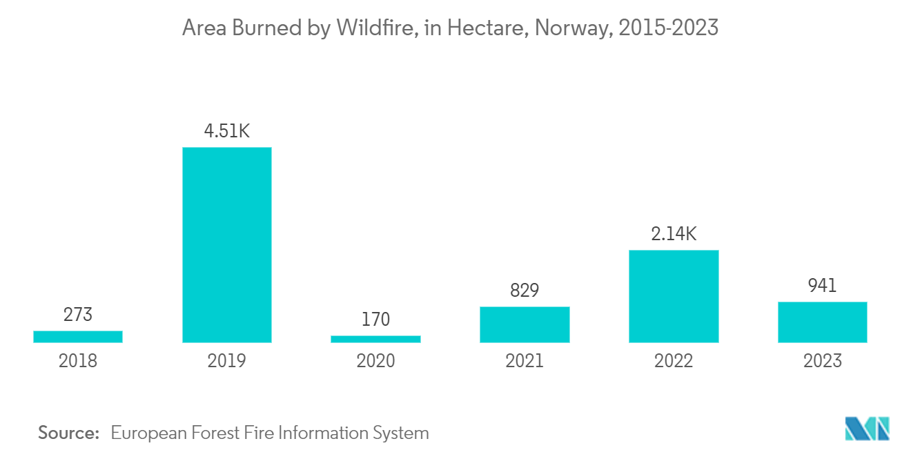
- Additionally, increasing wildfire incidents in Nordic countries due to changing climate and drier weather conditions are driving the demand for satellite imagery services. With the assistance of satellite imagery services, wildfire events can be monitored in almost real-time, and their aftermath can be easily evaluated. For instance, according to the data from European Forest Fire Information System, as of October 2022, 2,143 hectares of land were burned by wildfires in Norway.
- Moreover, the increasing focus on efficient and sustainable agriculture practices in the region is expected to drive the demand for satellite imagery services in the region's agriculture sector. Through the analysis of satellite imagery, farmers can track crop health, assess soil characteristics, and identify susceptibility to pests, diseases, and other risks. Integrating satellite imagery into precision agriculture practices can also significantly enhance sustainability and intelligence in the field. Such factors are expected to drive the demand for satellite imagery services in the forestry and agriculture industry over the forecast period.
Understand The Key Trends Shaping This Market
Download PDF
Sweden is Expected to Witness Substantial Traction
- The Sweden satellite imagery services market is analyzed to grow at a significant rate owing to the increasing demand across various end-user sectors, the presence of major market vendors such as OHB Sweden, and the increasing demand for satellite imagery services in the country's government sector. Further, the demand for satellite imagery services is also expected to combat climate change issues in the country.
- Climate change in Sweden due to future increases in atmospheric temperature will accelerate erosion through rising sea levels. Satellite imagery services can significantly help government authorities to combat climate change and help in disaster management in the country. Satellite images are taken frequently to measure temperatures and rainfall. They can inform the authorities about the spread of drought, leaf area, pollution, etc.
- Moreover, the booming space sector in the country is analyzed to aid the growth of the satellite imagery services market in the coming years. Swedish space companies are internationally competitive and indulging in innovative satellites. The Swedish National Space Agency (SNSA) contributes to Swedish space operations through calls that allow companies to develop new innovative products and services from satellites.
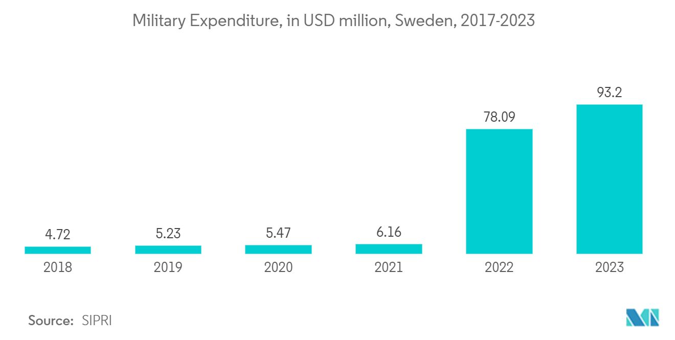
- The millitary and defense sector in the country is expected to witness growth in adoption of satellite imagery services as high-resolution satellite imagery enable millitary and defense agencies to detect and monitor potential targets. Moreover, the increasing millitary budget in past few years in the country offers growth potential for the adoption of satellite imagery services in millitary and defense sector. For instance, according to the data from SIPRI, the military expenditure in Sweden reached SEK 78,094 million (USD 7746.92 million) in 2022 compared to SEK 47,323 million (USD 5550.98 million) in 2017.
Get Analysis on Important Geographic Markets
Download PDF
