Market Trends of Middle East Geospatial Analytics Industry
Surface Analysis is Expected to Hold Significant Share of the Market
- Surface or terrain analysis focuses on studying topography-related information, such as aspect, volume, slope, hydrology, and other relevant characteristics. Surface analysis is widely used in disaster mitigation and location planning, as they effectively use esoteric mapping to determine the probability of disasters. The general surface characteristics (such as slope, aspect, and curvature) are largely used for analyzing the variations in the surface of a study object.
- For instance, the 'slope' metric is extensively used to define the areas of a region that are highly prone to landslides, whereas 'curvature' is used to determine areas prone to damage. In addition, the slope aspect can be used with geological structures to assess rock beds that may be useful for planning roads and other constructions, especially in hilly terrains. Furthermore, the 'slope' metric is extensively used to define the areas of a region that are highly prone to landslides, whereas 'curvature' is used to determine areas prone to damage.
- Furthermore, visibility analysis is conducted to identify areas during location planning, in which case, locations with expansive views are recognized as vantage points. Surface analysis is also widely used during the construction/renovation of large sites, wherein the volume of materials required to be dumped in open areas to avert erosion is determined.
- The increasing development of smart cities across the region is one of the key factors driving the market's growth. The increasing development of smart cities across the region is one of the key factors driving the market's growth. For instance, according to experts during an online event, Qatar Free Zones Authority (QFZA) is concentrating its business development efforts on attracting, partnering with, and investing in global enterprises to construct technological clusters to assist the country in accomplishing its goals. In Qatar, two large smart cities of the future are now under construction: Msheireb Downtown, a USD 5.5 billion mixed-use area encompassing 31,000 square meters, and Lusail Metropolis, a USD 45 billion smart city covering 38 square kilometers.
- The collaboration of firms to explore regional geothermal resources would drive the demand for surface analysis. For instance, in November 2022, SLB is cooperating with Oman's Ministry of Energy and Minerals and the Oman Investment Authority in creating a national strategy to expand the possibility of Oman's geothermal resources. This information follows the completion of an extensive project to assess data from more than 7,000 oil, gas, and water wells to map sweet spots for geothermal opportunities in the country. Commissioned by the Omani management, the SLB specialists assessed surface, subsurface, and well data from the national data repository over three months.
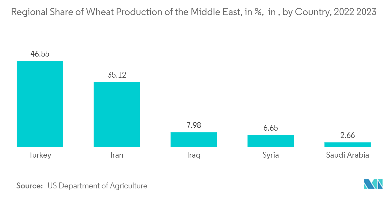
- Surface analysis can be further used for ecological zoning, land suitability classification, and probability mapping. Agricultural suitability and probability of soil erosion are two examples where geospatial data may be extensively used to best use the available land and limited agricultural labor. For instance, according to the US Department of Agriculture, Turkey was the leading contributor to regional wheat production within the Middle East region, with a share of 46.55 percent, as of the marketing year 2022/2023.
Understand The Key Trends Shaping This Market
Download PDF
Utility and Communication is Expected to Hold Significant Share of the Market
- Utility and Communication is a prominent end-user industry that has adopted geospatial analytics. The segment contains mostly energy and power, and communication systems. Analytic techniques used in the sector determine energy consumption profiles of high-resolution buildings using a method that combines annual energy simulations of various city-specific prototypical assets and geospatial data from the Geographical Information System (GIS) framework.
- The United Arab Emirates introduced "Energy Policy 2050," the nation's first comprehensive supply-and-demand-based energy strategy. The strategy intends to save AED 700 billion by 2050 and boost the share of renewable energy in the whole energy mix from 25% to 50%. It also aspires to lower the carbon footprint of power generation by 70%. Additionally, it aims to improve corporate and individual consumption efficiency by 40%. Such policies by the government will significantly create an opportunity for the market to grow.
- The increase in electricity production will drive the studied market. For instance, in July 2022, By 2025, Iraq was to generate more than 41,000 megawatts (MW) of power because of new initiatives and plans to upgrade existing utilities. When domestic power demand is anticipated to reach 41,225 MW in 2025, the cabinet has authorized a "plan" to meet that objective. As local demand is anticipated to reach that level in 2025, the policy aims to grow the nation's overall power production to 41,225 MW.
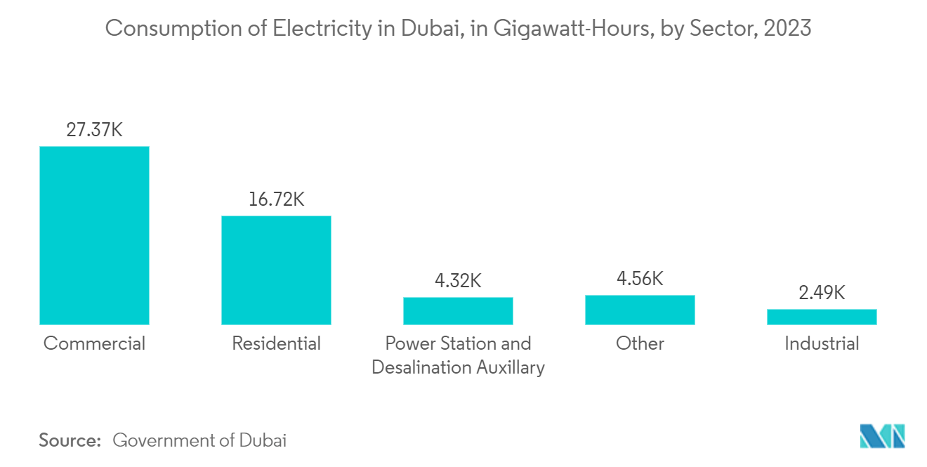
- According to Dubai Electricity and Water Authority, In 2023, the total electricity consumption by the commercial sector of the emirate of Dubai in the United Arab Emirates exceeded approximately 27,368 terawatt-hours. The number of electricity consumers in Dubai exceeded one million in the same year. Such huge consumption would increase the construction of new power plants, proportionately raising the demand for the studied market.
- Communications companies are taking the help of geospatial analytics to determine the location of new cell phone tower installations. Geospatial data obtained from the devices is used to measure signal strength from particular towers in that location, and the range of that signal is used to understand the lack of coverage and signal strength. Various parameters, like population density, road positioning, and customer location, are considered when deciding the location of the new cell tower installation.
Get Analysis on Important Geographic Markets
Download PDF
