
Middle East Geospatial Analytics Market Size and Share
Market Overview
| Study Period | 2020 - 2031 |
|---|---|
| Forecast Data Period | 2026 - 2031 |
| Base Year Market Size (2025) | USD 4.97 Billion |
| Market Size (2026) | USD 5.37 Billion |
| Market Size (2031) | USD 7.87 Billion |
| Growth Rate (2026 - 2031) | 7.95 % |
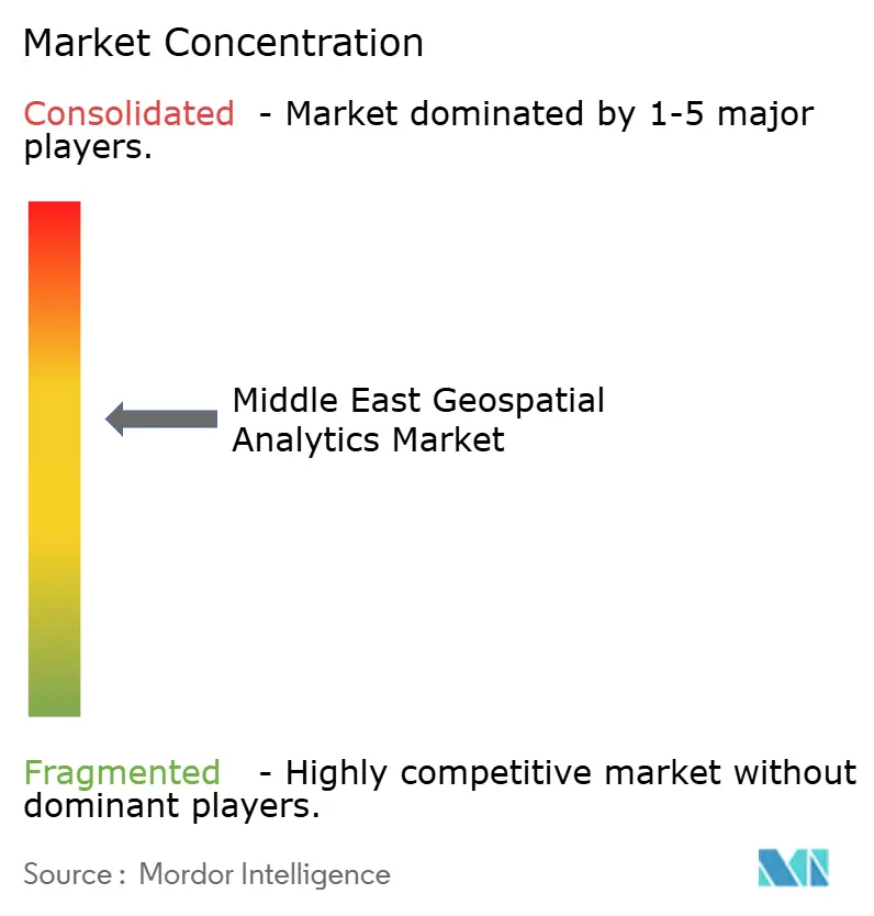
| Market Concentration | Medium |
Major Players *Disclaimer: Major Players sorted in no particular order Image © Mordor Intelligence. Reuse requires attribution under CC BY 4.0. | |
Middle East Geospatial Analytics Market Analysis by Mordor Intelligence
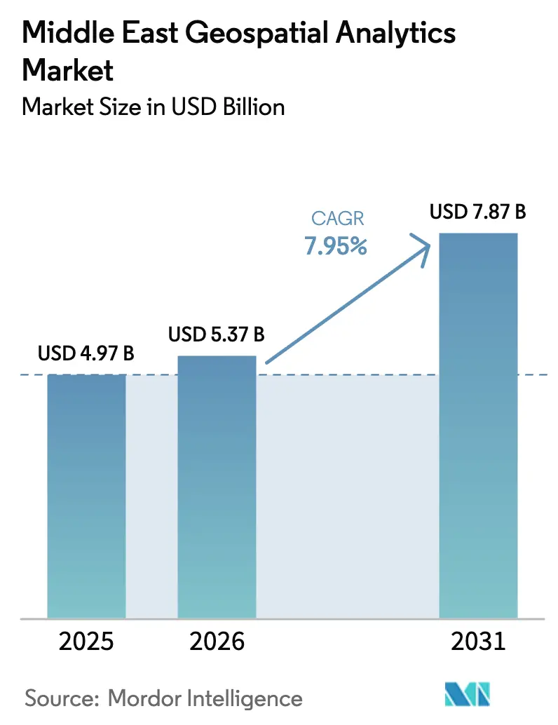
The Middle East Geospatial Analytics Market size was valued at USD 4.97 billion in 2025 and estimated to grow from USD 5.37 billion in 2026 to reach USD 7.87 billion by 2031, at a CAGR of 7.95% during the forecast period (2026-2031). Accelerated smart-city programs, massive public-sector digital-twin projects, and sovereign data-center investments are reinforcing demand for spatial intelligence platforms. Government modernization agendas such as Saudi Arabia’s Vision 2030 and the UAE’s National AI Strategy 2031 are allocating multibillion-dollar budgets that anchor technology adoption in construction, utilities, mining, and defense. Rapid cloud build-outs, exemplified by a 36% annual increase in AI infrastructure spending in the UAE, are lowering entry barriers for smaller enterprises while creating scale for edge-enabled processing. [1] Competitive intensity is heightening as global geospatial software vendors face cloud hyperscalers and a wave of UAE free-zone geo-AI start-ups. Persistent skills shortages in deep-learning GIS, plus the rising cost of LiDAR and synthetic-aperture-radar sensors, act as structural constraints that could temper project roll-outs.
Key Report Takeaways
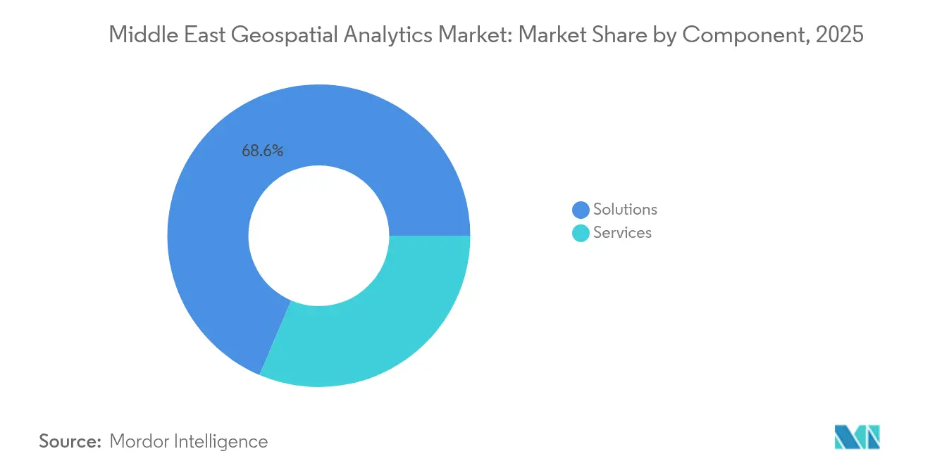
- By component, solutions led with 68.60% of the Middle East geospatial analytics market share in 2025, while services are expanding at an 11.05% CAGR through 2031.
- By analytics type, descriptive analytics accounted for 43.25% revenue share in 2025; prescriptive analytics is set to grow at a 10.28% CAGR to 2031.
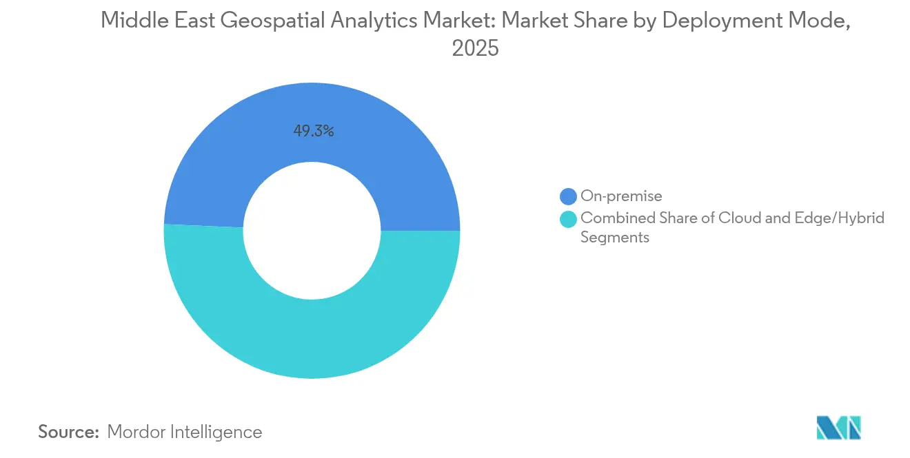
- By deployment mode, on-premise systems held 49.30% share of the Middle East geospatial analytics market size in 2025, whereas cloud deployments are projected to rise at an 11.18% CAGR over the forecast period.
- By application, imagery and remote-sensing analytics captured 33.55% revenue share in 2025, and geovisualization and 3-D modeling are forecast to expand at a 10.57% CAGR through 2031.
- By end-user industry, government and municipalities commanded a 28.65% share in 2025, while utilities and energy lead growth at a 10.33% CAGR.
- By country, Saudi Arabia held a 41.25% share in 2025, and Qatar is poised for the fastest 10.88% CAGR to 2031.
Note: Market size and forecast figures in this report are generated using Mordor Intelligence’s proprietary estimation framework, updated with the latest available data and insights as of 2026.
Dynamics observed within Middle east present a holistic view when set against the broader international context. The geospatial analytics market analysis by Mordor Intelligence provides that expanded global perspective.
Market Trends and Insights
Drivers Impact Analysis of Middle East Geospatial Analytics Market*
| Driver | (~) % Impact on CAGR Forecast | Geographic Relevance | Impact Timeline |
|---|---|---|---|
| Surging smart-city programs across GCC | +2.1% | UAE, Saudi Arabia, Qatar | Medium term (2-4 years) |
| Mandated satellite-based cadastral modernization | +1.8% | Saudi Arabia, UAE, Oman | Long term (≥ 4 years) |
| Rapid cloud-GIS migration by utilities | +1.5% | GCC countries, Turkey | Short term (≤ 2 years) |
| 5G-enabled edge analytics roll-outs | +1.4% | UAE, Saudi Arabia | Medium term (2-4 years) |
| Rise of geo-AI startups in UAE free zones | +0.9% | UAE (regional spill-over) | Short term (≤ 2 years) |
| Oil-to-non-oil economic diversification projects | +1.3% | Saudi Arabia, UAE, Qatar | Long term (≥ 4 years) |
| Source: Mordor Intelligence | |||
Surging Smart-City Programs Across GCC
Gulf megaprojects are hard-wiring geospatial analytics into urban-management architectures. Dubai’s 2040 Urban Master Plan doubles green areas while targeting a population of 7.8 million, demanding real-time spatial modelling for the “20-minute city” concept. [2] Saudi Arabia’s partnership with Naver is delivering 10-cm resolution 3-D twins for Riyadh and four additional cities, enabling flood simulation and infrastructure optimisation. The USD 2.5 billion Aion Sentia platform in the UAE integrates AI-driven spatial data to orchestrate city services end-to-end. These projects create predictable, multi-year demand for high-volume imagery ingestion, advanced routing analytics, and predictive maintenance models inside the Middle East geospatial analytics market.
Mandated Satellite-Based Cadastral Modernization
New land-registration statutes require sub-meter accuracy and audit trails, pushing agencies toward cloud-enabled spatial data infrastructures. Saudi Arabia’s draft Global AI Hub Law outlines “Private,” “Extended,” and “Virtual” hubs, formalising sovereign hosting while enabling cross-border cadastral integration. The UAE’s MBZ-SAT will lift domestic earth-observation capacity, accelerating update cycles for parcel databases. Kuwait demonstrates downstream value: its utilities ministry cut service-connection times after embedding cadastral layers into a GIS workflow. Standardised cadastral basemaps unlock richer analytics in taxation, infrastructure planning, and environmental monitoring.
Rapid Cloud-GIS Migration by Utilities
Utilities adopt distributed clouds to process petabyte-scale sensor feeds without high on-premise capital outlays. Aramco’s partnership with Microsoft and Armada has deployed the world’s first industrial distributed cloud, combining edge nodes with regional hyperscale zones to automate safety monitoring of energy assets. Etisalat leverages 5G edge computing with Intel and Lenovo to serve low-latency utility IoT workloads. Similar projects across Kuwait’s Digital Integrated Field prove that private-cloud GIS trims data-ingestion delays and improves asset-lifecycle visibility. The Middle East geospatial analytics market benefits as utilities outsource complex model management to managed-service providers.
5G-Enabled Edge Analytics Roll-Outs
Coverage expansion and a dense micro-data-center footprint reduce round-trip latency to milliseconds, vital for autonomous systems and situational awareness. Qualcomm and e& inaugurated an Abu Dhabi engineering center to co-design 5G edge-AI gateways for smart mobility and industrial automation. Saudi Telecom Company’s 54.7% population coverage supports more than 25 tier-III data centers, delivering the backhaul critical for high-frequency geolocation updates. These infrastructures embed real-time geospatial processing into field operations, deepening market penetration in logistics, oil, and public safety.
Restraints Impact Analysis of Middle East Geospatial Analytics Market*
| Restraint | (~) % Impact on CAGR Forecast | Geographic Relevance | Impact Timeline |
|---|---|---|---|
| Geospatial-data sovereignty regulations | -1.2% | Saudi Arabia, UAE, regional spillover | Medium term (2-4 years) |
| Skilled-talent shortage for deep-learning GIS | -1.8% | Regional, acute in UAE and Saudi Arabia | Long term (≥ 4 years) |
| Fragmented legacy cadastral datasets | -1.1% | Saudi Arabia, UAE, Oman, Turkey | Long term (≥ 4 years) |
| High LiDAR and SAR acquisition costs | -0.9% | Global, particularly affecting smaller regional players | Short term (≤ 2 years) |
| Source: Mordor Intelligence | |||
Geospatial-Data Sovereignty Regulations
Fragmented localisation mandates elevate compliance overheads for multinational deployments. Saudi Arabia’s draft Global AI Hub Law prescribes three distinct hosting archetypes with divergent audit obligations, complicating regional data-lake architectures. The UAE’s localisation rules force foreign providers to build local points of presence or enter joint ventures, lengthening deployment timelines. Intensifying Chinese hyperscaler expansion in the Gulf introduces geopolitical scrutiny over platform selection and encryption standards. These dynamics squeeze smaller vendors and prolong procurement cycles within the Middle East geospatial analytics market.
Skilled-Talent Shortage for Deep-Learning GIS
The gap in AI-ready geospatial engineers drives salary inflation and project delays. CIO reports persistent ICT skill deficits that risk billions in unrealised regional output. Saudi Arabia’s plan to up-skill 1,000 engineers under Vision 2030 and the UAE’s “One Million Arab Coders” initiative illustrate long-term remediation, yet specialised geo-AI curricula remain scarce. AgFunder highlights shortages in climate-smart-agriculture technologists, signaling how niche verticals struggle even more acutely. A thinner talent pipeline slows adoption of advanced analytics modules and increases dependency on external service firms.
*Our forecasts treat driver/restraint impacts as directional, not additive. The impact forecasts reflect baseline growth, mix effects, and variable interactions.
Middle East Geospatial Analytics Market Segment Analysis
By Component:
Services Gaining MomentumSolutions continued to dominate the Middle East geospatial analytics market with a 68.60% share in 2025, reflecting entrenched investments in software suites and sensor hardware. However, the services segment is expanding at an 11.05% CAGR as ministries and enterprises outsource integration, model training, and 24/7 managed analytics. Regional shortages in deep-learning GIS specialists make vendor-delivered professional services the pragmatic route for rapid roll-out. Governments favour turnkey frameworks that bundle data-ingestion pipelines, sovereign cloud hosting, and Arabic language interfaces.
Service providers leverage strategic alliances to deepen vertical intimacy. Bentley Systems integrated Google geospatial content to deliver richer context within digital-twin workflows, underpinning infrastructure-as-a-service offerings. Managed-service portfolios now include continuous satellite imagery updates, AI model retraining, and cyber-resilience audits. This evolution positions the services cohort to capture rising OPEX budgets as the Middle East geospatial analytics market prioritises speed over in-house capability building.

By Analytics Type:
Prescriptive Analytics AdvancingDescriptive analytics retained 43.25% revenue share in 2025 by providing dashboards and historical pattern recognition across land, asset, and population datasets. Yet prescriptive analytics is growing 10.28% annually, propelled by demand for automated optimisation in traffic orchestration, energy load balancing, and emergency-response routing. Defence conglomerate EDGE unveiled an AI-enabled geospatial platform able to recommend and auto-execute mission-critical manoeuvres, underscoring momentum toward action-oriented engines.
Organisations move through a maturity curve starting with descriptive and evolving to predictive, diagnostic, and finally prescriptive; budget allocations increasingly prioritise the latter stages. Confidence in AI explainability, combined with 5G edge connectivity, allows decision loops to compress from minutes to seconds, boosting market penetration for higher-value analytics tiers within the Middle East geospatial analytics market.
By Deployment Mode:
Cloud Transformation AcceleratingOn-premise architectures accounted for 49.30% of the Middle East geospatial analytics market size in 2025, mirroring historical preferences for data-sovereign control. Cloud deployments, however, are scaling at an 11.18% CAGR as hyperscale build-outs across the GCC foster elastic compute economics. Saudi Arabia’s data-center pipeline—projected to reach USD 15.9 billion by 2030—offers low-latency colocation that meets stringent localisation rules while retaining hyperscale flexibility.
Edge and hybrid models combine in-country micro-DCs with regional cores, catering to latency-sensitive mining and oilfield scenarios. Utilities adopt distributed clouds to host geofenced digital twins, satisfying regulators yet enjoying consumption-based pricing. This convergence of compliance and cloud economics propels the Middle East geospatial analytics market toward an infrastructure-agnostic paradigm.
By Application:
Geovisualization and 3-D Modeling EmergingImagery and remote-sensing analytics led with a 33.55% share in 2025, validating the primacy of multispectral and SAR data streams for asset monitoring and land-use mapping. Geovisualization and 3-D modeling are the fastest-growing applications at 10.57% CAGR, catalysed by mega-projects like NEOM and digital-twin mandates across transport corridors. Live, immersive models support construction sequencing, underground-utility clash detection, and urban-heat-island mitigation.
The Dubai Metro digital twin improves passenger-flow simulations, while Saudi projects achieve 10-cm positional accuracy for flood-risk analytics. Advancements in GPU-accelerated rendering and cloud-native scene services let planners manipulate terabyte-scale point clouds through browser interfaces. These capabilities expand addressable use cases and reinforce the trajectory of the Middle East geospatial analytics market.
By End-user Industry:
Utilities and Energy TransformationPublic administrations remained the largest customers, securing 28.65% of 2025 revenue due to cadastral modernisation, smart surveillance, and emergency-response optimisation. Utilities and energy companies record the highest 10.33% CAGR as they retrofit networks for renewables integration and predictive maintenance. Aramco’s distributed cloud enables millisecond-level leak detection, while Kuwait’s utilities ministry shortened connection cycles after a GIS overhaul.
The Middle East geospatial analytics market benefits from decarbonisation agendas that require spatial optimisation of solar assets, hydrogen pipelines, and EV-charging nodes. Sector-specific modules now include corrosion-risk heatmaps and dynamic load-balancing algorithms, underpinning higher subscription renewals and multi-year managed-services contracts.
Geography Analysis
Saudi Arabia Geospatial Analytics Market
Saudi Arabia commanded 41.25% of the Middle East geospatial analytics market in 2025 as Vision 2030 funded smart-city, mining, and defence modernisation on an unprecedented scale. A dedicated USD 100 billion AI allocation and an additional USD 40 billion investment vehicle support satellite programs and sovereign cloud zones. NEOM’s adaptive-twin architecture and a mining roadmap chasing USD 75 billion GDP contribution by 2035 secure long-run project pipelines.
United Arab Emirates Geospatial Analytics Market
The UAE positions itself as an AI innovation nucleus through MBZ-SAT, Space42, and heavy 5G backhaul, accelerating adoption across defence, urban planning, and logistics. Dubai’s 2040 master plan underpins continuous demand for terrain deformation analysis and green-space optimisation. Abu Dhabi’s sovereign wealth fund backing of edge-AI start-ups fills white spaces in predictive geospatial intelligence offerings. Collectively, these initiatives deepen the UAE’s strategic share of the Middle East geospatial analytics market.
Middle East and APAC Geospatial Analytics Market
Qatar is forecast to log an 10.88% CAGR through 2031, buoyed by FIFA World Cup infrastructure repurposing and National Vision 2030 digitisation goals. Showcases such as “Qatar GIS of the Future” highlight the government's appetite for high-resolution satellite data integration. Turkey, Oman, and Bahrain promote complementary growth. Turkey’s industrial base generates sustained imagery demand, while Oman nurtures a space-accelerator programme that feeds regional supply chains. The evolving space economy across Asia and the Gulf broadens cross-border collaboration prospects, reinforcing the scale of the Middle East geospatial analytics market.
Coverage of the geospatial analytics market by Mordor Intelligence spans a wide geographic footprint, with regional analysis available for Africa, alongside detailed country-level intelligence for United Arab Emirates, Saudi Arabia, Israel, Nigeria, Canada, South Korea, India, and Brazil, each shaped by local operating conditions.
Regulatory Landscape
Geospatial analytics deployments in the Middle East are increasingly shaped by national geospatial data governance programs that define data classification, sharing, and residency requirements for public-sector and critical-infrastructure use cases. In Saudi Arabia, the General Authority for Survey and Geospatial Information (GEOSA) publishes National Geospatial Data Policies and Standards covering licensing, pricing, sharing, and protection of geospatial data, anchoring compliance to recognized geospatial practices while aligning controls with national cybersecurity requirements.
Across the region, policy formalization is tightening coordination across agencies and setting clearer obligations for vendors and integrators. The UAE Federal Geographic Information Center (FGIC), established under Federal Law No. 5 of 2019, supports the National Spatial Data Infrastructure (NSDI) through national geospatial information policy. Oman added a regulatory milestone with Royal Decree 43/2026 (issued 30 March 2026) to regulate national geospatial data and information, reinforcing requirements for compliant data handling, controlled dissemination, and fit-for-purpose hosting models for government and regulated industries.
Value Chain Analysis
The Middle East geospatial analytics value chain starts with data acquisition and baseline data management, covering satellite imagery, aerial mapping, LiDAR/photogrammetry, GNSS positioning, and IoT sensor feeds used in smart-city and critical-asset monitoring. National mapping and geospatial authorities shape the upstream layer by standardizing and brokering foundational datasets through platforms and policies. In Saudi Arabia, for example, GEOSA operates a National Geospatial Platform with multiple foundation themes (land parcels, transport, utilities, and administrative regions), which downstream users consume for analytics and operational workflows.
Midstream, software and platform providers supply the analytics stacks and digital-twin toolchains used to fuse, model, and visualize spatial data. Key ecosystems include Esri (enterprise GIS), Bentley Systems (digital twins and reality modeling), and Hexagon (measurement, sensors, and autonomy-oriented solutions). System integrators and engineering firms localize deployments and connect geospatial platforms to enterprise and operations systems. Examples include Khatib & Alami delivering geospatial intelligence programs in the GCC and Oman, alongside project-driven implementations for public authorities and large asset owners. Downstream demand is concentrated in government and municipalities, with expansion across utilities and energy, mining, transport, and ports, where delivered outcomes include real-time situational awareness, asset performance monitoring, and 3-D city modeling integrated into planning and emergency-response operations.
Competitive Landscape
The competitive arena displays moderate fragmentation. Incumbents such as Esri, Hexagon, and Trimble leverage decades-old ecosystems, whereas cloud hyperscalers add geospatial capability through API portfolios and acquisitions. Microsoft’s Azure Orbital, Google’s Earth Engine, and Amazon Location Services embed spatial analytics into broader developer toolkits, pressuring traditional license models. Meanwhile, regional specialists like Bayanat commercialise sovereign datasets and AI pipelines tailored to Arabic semantics and local compliance contexts. [4]
Edge-computing differentiation is intensifying. Telecommunications carriers co-develop spatial SDKs with chipset firms to package low-latency analytics for drones, autonomous trucks, and critical-event monitoring. Qualcomm’s collaboration with e& illustrates hardware-software convergence that incumbents must match. In addition, procurement criteria increasingly reward adherence to sovereign-cloud statutes, pushing vendors to certify data-center residencies and encryption schemes.
Mergers and venture-backed alliances accelerate feature expansion: Maxar deepened 3-D city-mesh production via Blackshark.ai, and Bentley-Google integration streamed point-cloud context into engineering workflows. As talent remains scarce, vendors bundle training academies and low-code modelling to lock in customer bases. Collectively, these dynamics sustain a vibrant yet contested Middle East geospatial analytics market.
Middle East Geospatial Analytics Industry Leaders
-
Esri Inc.
-
Hexagon AB
-
Trimble Inc.
-
Bentley Systems Inc.
-
Maxar Technologies
- *Disclaimer: Major Players sorted in no particular order
Middle East Geospatial Analytics Market Companies Covered in this Report
- Esri Inc.
- Hexagon AB
- Trimble Inc.
- Bentley Systems Inc.
- Maxar Technologies
- HERE Technologies
- CARTO
- Planet Labs PBC
- Space Imaging Middle East
- Openware
- MindEarth AI
- Alteryx Inc.
- Oracle Corporation
- Google LLC (Alphabet)
- Microsoft Corp.
- AWS (Amazon Web Services)
- IBM Corporation
- SAP SE
- TomTom N.V.
- Fugro N.V.
- BlackSky Technology Inc.
- Airbus Defence & Space
- Harris Geospatial Solutions
- Eos Data Analytics
- AtkinsRéalis
Market Opportunities and Future Outlook
National and city-scale digital twin programs are expanding the implementation surface for high-resolution 3-D modeling, change detection, and real-time operations dashboards. Dubai announced a real-time Digital Twin Platform integrating 195,000 buildings and 330,000 facilities to support infrastructure and emergency planning, while Qatar has operationalized a national 3D City Model with more than 43,000 LOD2 textured buildings delivered via the Esri ArcGIS platform for urban planning workflows. These programs create opportunities for vendors that can operationalize continuous updates, such as imagery refresh, automated feature extraction, and event-driven alerts, rather than one-time mapping.
A second whitespace is emerging in national geospatial data products and domain-specific analytics that reduce fragmentation across agencies and regulated operators. GEOSA runs an initiative in Riyadh to collect and classify more than 300,000 points of interest to update a unified national geospatial database, increasing demand for scalable data pipelines, QA automation, and governance tooling that can be packaged as managed services. Sector-led programs also widen addressable needs for analytics embedded into operations, including Al Madinah Region Development Authority's Manarah urban data platform built with Bentley iTwin Capture and Cesium for pilgrimage infrastructure and heritage management, and Ma'aden deploying Hexagon technologies for a digital mine at Mansourah-Massarah, which raises requirements for high-frequency spatial telemetry, autonomous operations support, and integrated planning across large sites.
Recent Industry Developments in Middle East Geospatial Analytics Market
- July 2026: Dubai-based Planno secured a strategic investment from Incubayt Investments to accelerate international expansion of its geospatial AI platform for the solar industry. The investment expands Planno's geospatial AI footprint and enables international deployment for solar analytics. The move signals stronger market traction in the Middle East for geospatial driven solar asset optimization.
- May 2026: GeoStruXer completed rehabilitation of a sinking grain warehouse at Jazan City Port using Bentley Systems PLAXIS 3D software and AI-assisted modeling. The project demonstrates advanced geospatial-enabled civil engineering workflows in Saudi Arabia. It highlights how integrated modeling and AI-assisted workflows can improve structural resilience in critical infrastructure.
- March 2026: Khatib & Alami commenced Esri GIS System Design and real-time services implementation at Petroleum Development Oman (PDO). The deployment strengthens regional digital sovereignty and real-time geospatial capabilities. It advances Oman's oil and gas operations with live location based decision making.
Middle East Geospatial Analytics Market Report Scope and Research Methodology
Market Definition and Coverage
This market covers spending in the Middle East on software, platforms, and related services that analyze location-based data to generate maps, patterns, and insights for decisions in government and commercial use cases.
Scope exclusions: This sizing excludes general IT consulting that is not linked to geospatial analytics delivery, as well as pure hardware-only sales like drones, sensors, and GNSS devices.
Segments Covered in This Report
- By Component
- Solutions
- Services
- By Analytics Type
- Descriptive Analytics
- Diagnostic Analytics
- Predictive Analytics
- Prescriptive Analytics
- By Deployment Mode
- On-premise
- Cloud
- Edge/Hybrid
- By Application
- Surface and Terrain Analysis
- Network and Route Analysis
- Geovisualization and 3-D Modelling
- Imagery and Remote-Sensing Analytics
- By End-user Industry
- Defense and Intelligence
- Government and Municipalities
- Utilities and Energy
- Agriculture and Environment
- Transportation and Logistics
- Real Estate and Construction
- Mining and Natural Resources
- Healthcare and Public Health
- Other End-user Industries
- By Country
- United Arab Emirates
- Saudi Arabia
- Turkey
- Qatar
- Oman
- Rest of Middle East
Data Sources, Market Sizing, and Validation
Desk Research
Desk research was used to set the starting structure for the model and to build a fact base on where demand is coming from across the Middle East. We reviewed public planning and digitization signals, procurement cues, and geospatial program announcements to understand which end uses were moving from pilots to scaled deployments.
The main public sources were a mix of official data and technical publications such as national statistics portals, telecom and digital government authorities, UN and World Bank data series, and geospatial and remote sensing publications (including open research journals). We also used company filings, investor presentations, credible press releases, and selected paid subscriptions for company financials and patent databases to sanity-check product direction and pricing logic. These desk sources are illustrative only, and additional public documents and datasets were used for collection, clarification, and validation.
Primary Interviews and Surveys
Primary work focused on validating what is actually being purchased in the region and how deployments are being priced, packaged, and renewed over time. We spoke with a mix of solution leaders, delivery partners, and end users across public sector, utilities, oil and gas, transport, and smart city programs, which helped close gaps that desk sources do not always explain.
To keep assumptions realistic, feedback was compared across GCC and non-GCC demand pockets, and follow-ups were done when answers differed on topics like cloud adoption timing, imagery refresh needs, and typical contract lengths.
Distribution of primary research fieldwork respondents
| Company type | Respondent position |
|---|---|
| Top tier: 38% | CXOs: 16% |
| Mid tier: 46% | Functional/Unit leaders: 38% |
| Smaller Players: 16% | Managers: 46% |
Market-Sizing & Forecasting
Sizing starts with a top-down demand pool build using Middle East digital infrastructure and geospatial program signals, which is then translated into addressable spending based on adoption and use intensity by end-user groups. After that build-up, we cross-checked with selective bottom-up approximations such as sampled contract values, channel feedback on typical license and service bundles, and price-per-user or price-per-project checks where applicable.
A few practical inputs guided the model, including the pace of smart city and infrastructure project pipelines, defense and public safety modernization activity, the cloud versus on-premise deployment mix, imagery and data refresh frequency for key applications, and the availability of local geospatial data policies that influence where data can be processed. Where supplier roll-ups were incomplete due to private revenue disclosures, gaps were handled using peer benchmarking and a service-to-software mix observed in interviews, then adjusted after variance checks.
Forecasts were built using scenario analysis supported by an exponential smoothing trend on the most stable demand drivers, and then refined using expert views on budget cycles, procurement lead times, and expected changes in pricing over the next few years.
Data Validation & Update Cycle
Validation was done through multiple checks so the final totals align with real-world buying patterns. Model outputs were compared with independent signals like public tenders, program timelines, and directionally consistent spending capacity in key countries, and unusual jumps were investigated before values were locked.
A multi-step review is followed, where assumptions and calculations are rechecked by another analyst and then reconciled back to the written scope to avoid double counting. The study is refreshed annually, and interim updates are made when material events occur, such as major policy changes, large public awards, or sharp shifts in cloud adoption. Before delivery, a fresh pass is completed so clients receive the latest updated view.
Mordor Intelligence's Middle East Geospatial Analytics Market Sizing Compared With Other Published Estimates
Published market sizes for Middle East geospatial analytics can look far apart, even when the topic sounds the same, because each publisher makes different calls on what counts as analytics revenue and how multi-country projects are allocated. Differences also show up from the year used for currency conversion and whether the estimate reflects signed contracts or recognized revenue.
The largest gap drivers we observed were whether adjacent spend like raw imagery services and mapping-only tools are added into the total, how cloud subscriptions are annualized versus treated as multi-year deals, and how country coverage is defined (GCC-only versus wider Middle East). Another common reason is refresh cadence, since fast-moving government programs can change the short-term run rate quickly, and older pages may still carry earlier procurement assumptions.
Benchmark comparison
| Source | Market Size | Gaps in Research Methodology |
|---|---|---|
| Mordor Intelligence | USD 4.97 B (2025) | |
| Regional Consultancy A | USD 3.60 B (2023) | Uses an earlier base year and often blends spatial analysis with broader data science spend, which can understate newer geospatial analytics subscription revenue and shifts in cloud packaging. |
| Industry Publisher B | USD 1.18 B (2026) | Applies a narrower definition that tends to exclude services tied to deployment and integration, and it appears to rely on a smaller demand pool for large government programs, which pulls the total down. |
The spread in the table mainly comes from what is counted inside the analytics spend and how quickly pricing and deployment assumptions are refreshed, and those choices impact the year-to-year run rate. By separating pure imagery and mapping-only tools from analytics software and related implementation work, and then revalidating the conversion timing and contract treatment through primary checks, the 2025 value stays traceable to repeatable steps, a modeling choice applied by Mordor Intelligence.
Key Questions Answered in the Report
What is the current value of the Middle East geospatial analytics market?
The market stands at USD 5.37 billion in 2026 and is forecast to reach USD 7.87 billion by 2031.
Which country leads regional demand?
Saudi Arabia accounts for 41.25% of revenue, buoyed by Vision 2030 and large-scale digital-twin investments.
Which segment is growing the fastest?
Cloud deployment shows the highest 11.18% CAGR because sovereign data-center build-outs are easing localisation concerns.
Why are services expanding rapidly?
Acute shortages in deep-learning GIS skills push organisations to outsource integration and model management, driving an 11.05% CAGR in services revenue.
How are smart-city projects influencing the market?
Megaprojects like Dubai’s Urban Master Plan and Saudi digital-twin initiatives demand continuous geovisualisation, accelerating platform subscriptions and 3-D modelling adoption.
What is the primary restraint on market growth?
Fragmented data-sovereignty regulations raise compliance costs and elongate deployment timelines, reducing the overall market CAGR by an estimated 1.2%.