Market Trends of Canada Geospatial Analytics Industry
Network Analysis is Expected to Hold Significant Share of the Market
- Network Analysis enables end-users to incorporate location-based information into their decision-making process. In several cases, firms must consider all possible cases for making effective decisions regarding cost and resources. GIS is widely used for studying real-world problems related to operations research and flow-related issues, such as transportation research. Some significant applications of network analysis in operations research include selecting the best route, shortest path analysis, optimal allocation of finite resources, network partitioning, selection of closest maintenance facility, and location-allocation, among others.
- The use of network analysis has gained prominence in today's cities, which are becoming increasingly congested. For instance, in the case of any emergency response system (ERS), the best route or shortest path analysis data using spatial data directly improves the fire emergency response, police station emergency response, healthcare emergency response system, etc. Google Maps extensively uses spatial data to provide multiple routes, the best routes, and real-time analysis to re-route in case the user cannot follow the suggested path.
- The players in the market are collaborating to provide better services to its customer and expand their market presence. For example, Mapbox, one of the prominent mapping and location cloud platforms for developers, and Ookla, the renowned company that developed Speedtest and Downdetector, have joined forces worldwide to develop ground-breaking network-aware mapping solutions. Technologies that offer significant new value to each company's customers will be developed together. Because of their combined capabilities and expertise, Ookla and Mapbox are uniquely positioned to transform connectivity-aware mapping features and geospatial network analysis.
- Geospatial network analysis is crucial in the mining industry to identify essential habitat patches and plan and manage mining operations. With the help of geographic information systems (GIS), spatial databases, and specialized software tools, mining companies can perform spatial analyses, create linear networks of interconnected features, and perform detailed spatial analyses on them.
- Such tools help identify ecological sources based on morphology, create vector-based network analysis to optimize transportation, and use spatial data mining to solve complex problems. According to US Geological Survey, Canada's gold production from mines was estimated to be 200 metric tons in 2023. Such huge mining capacity would drive the studied market.
- GIS network analysis has also been applied in Canada to solve transportation problems. For example, fleet management uses GIS network analysis to solve scheduling problems and stay on route. Network analysis tools in GIS have been used to perform multiple closest facility analyses, such as identifying the closest hospital or emergency services during an incident. Another application of geospatial network analysis in Canada is identifying influential nodes in the air pollution spatial correlation weighted network. Researchers have used spatial correlation analysis to analyze air pollution and identified influential cities to prioritize environmental interventions. .

Understand The Key Trends Shaping This Market
Download PDF
Utility and Communication is Expected to Hold Significant Share of the Market
- Utility and Communication is a prominent end-user industry that has adopted geospatial analytics. The segment contains mostly energy and power, and communication systems. Analytic techniques used in the sector determine energy consumption profiles of high-resolution buildings, using a method that combines annual energy simulations of various city-specific prototypical assets and geospatial data, from the Geographical Information System (GIS) framework.
- According to statcan, when compared to the same month a year earlier, hydroelectricity generation in Canada decreased by 4.1% to 34.9 million MWh in February 2022, despite continuing to be the single largest contributor to electricity generation in the country (62.1% of total generation). Additionally, the amount of electricity produced from combustible fuels, such as biomass, decreased by -8.4% to 10.4 million MWh. In February, increases in generation from wind power (+19.9 percent) and nuclear energy (+14.8%) were reported.
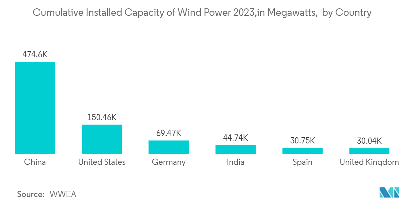
- China is the leading country in the world for installing wind power capacity, exceeding the United States which is ranked second. By the end of 2023, China had installed more than 464 gigawatts of wind power, whereas the United States had only installed 150 gigawatts of wind energy. By using geospatial technologies, it is possible to identify areas with high wind speeds and assess their potential for generating wind power.
- Communications companies in the region are taking the help of geospatial analytics to determine the location of new cell phone tower installations. Geospatial data obtained from the devices is used to measure signal strength from particular towers in that location, and the range of that signal is used to understand the lack of coverage and signal strength. Various parameters, like population density, road positioning, and customer location, are considered to decide the location of the new cell tower installation.
- Analysis of geospatial data can also allow communications companies to manage their assets effectively. For instance, a company can analyze geospatial data to understand the power outage vulnerability of a site in the event of a storm, thereby managing its network assets. Furthermore, the company can also understand the deployment of its service assets (such as repair crews) to determine how to position them in case maintenance is needed.