Market Size of Canada Geospatial Analytics Industry
| Study Period | 2019 - 2029 |
| Base Year For Estimation | 2023 |
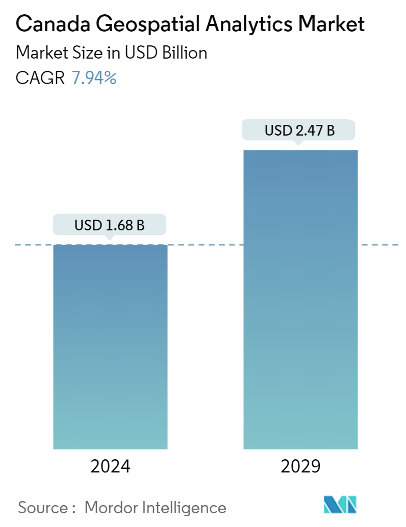
| Market Size (2024) | USD 1.68 Billion |
| Market Size (2029) | USD 2.47 Billion |
| CAGR (2024 - 2029) | 7.94 % |
| Market Concentration | Medium |
Major Players
*Disclaimer: Major Players sorted in no particular order |
Canada Geospatial Analytics Market Analysis
The Canada Geospatial Analytics Market size is estimated at USD 1.68 billion in 2024, and is expected to reach USD 2.47 billion by 2029, growing at a CAGR of 7.94% during the forecast period (2024-2029).
Geospatial analysis refers to a broad range of activities that emphasize applying various techniques to data comprising geographical or space-related characteristics. The increasing use of GPS devices, technological advancements in the field of GIS technology, recent trends in the integration and convergence of geospatial technologies, the emergence of new business models aimed at leveraging the demand for geospatial information, and the increased application of geospatial analytics in city and town planning are some of the primary factors driving the expansion of the market for geospatial analytics.
- Geospatial analytics may be helpful in construction. Builders and developers may make educated decisions based on data-driven insights about location, zoning, and available resources using Geographic Information Systems (GIS) tools. GIS technology may help with anything from site selection to project management in home development. GIS, for example, may be used to analyze the terrain of a possible construction site to assess its suitability for development. Furthermore, GIS may assist builders in identifying potential environmental dangers that must be considered during development.
- According to Canada Mortgage and Housing Corporation, The number of dwelling units under construction in Canada in December of 2022 was approximately 334,100. Further, according to StatCan, in 2022, there were 261.85 thousand housing units under construction. Such a vast number of residential buildings would drive the studied market. There is an increasing rate of urbanization, hence, to create self-sustaining cities where a diverse set of drivers, such as quality of life, economic development, energy faculty, mobility, governance, security, living conditions, free movement, and people, are in constant flux, geospatial technology is central to providing a technological platform that forms the backbone of a city.
- Further, the significant features that have made Geovisualization invaluable for today's businesses are thematic mapping, heat maps, drawing and querying, and data points that can be represented numerically and graphically.
- Drawing and querying help a business isolate a particular geographic area and learn more about its demographic profile against its current CRM. Ride-hailing start-ups like Uber are extensively using geovisualization. Uber's Kepler. Gl geospatial tool, now an open source, is a geospatial data visualization tool that doesn't require coding, works in the browser, doesn't need to be installed, can render millions of GPS points, and is simple to use.
- Conversely, implementing new technology brings with it new challenges that may involve privacy-related concerns, as in the case of GIS and other mapping technologies. There have been several instances where gathering geospatial data earned the wrath of regional privacy and demographics laws. Ideally, new technologies need to be embraced and integrated into the social discourse to enable end users to gain benefits.
- However, certain governmental agencies have been very cautious about the 'democratization' of data, specifically in the case of sensitive installations. Societal responses to privacy issues that have come up because of the integration of GIS and GPS have primarily been mixed. However, there has also been an overriding sense of optimism over the benefits geospatial data offers.
Canada Geospatial Analytics Industry Segmentation
Geospatial analytics is the process of acquiring, manipulating, and displaying imagery and data from the geographic information system (GIS), such as satellite photos and GPS data. The specific identifiers of a street address and a zip code are used in geospatial data analytics. They are used to create geographic models and data visualizations for more accurate trends modeling and forecasting.
The Canada geospatial analytics market is segmented by type (surface analysis, network analysis, geovisualization) , by end user vertical (agriculture, utility and communication, defence and intelligence, government, mining and natural resources, automotive and transportation, healthcare, real estate and construction). The market sizes and forecasts are provided in terms of value (USD) for all the above segments.
| By Type | |
| Surface Analysis | |
| Network Analysis | |
| Geovisualization |
| By End-user Vertical | |
| Agriculture | |
| Utility and Communication | |
| Defense and Intelligence | |
| Government | |
| Mining and Natural Resources | |
| Automotive and Transportation | |
| Healthcare | |
| Real Estate and Construction | |
| Other End-user Verticals |
Canada Geospatial Analytics Market Size Summary
The Canada geospatial analytics market is poised for significant growth, driven by the increasing adoption of GPS devices and advancements in Geographic Information Systems (GIS) technology. The market is experiencing a surge due to the integration and convergence of geospatial technologies, which are becoming integral in urban planning and development. The application of geospatial analytics in construction, city planning, and various industries such as utilities and communications underscores its importance. These technologies enable data-driven decision-making, enhancing efficiency in site selection, project management, and resource allocation. The rise in urbanization and the need for self-sustaining cities further propel the demand for geospatial analytics, as they provide critical insights into urban dynamics and infrastructure development.
The market landscape is moderately consolidated, with key players like Harris Corporation, Bentley Systems, and ESRI Inc. actively investing in strategic partnerships and product innovations to expand their market presence. Collaborations, such as those between Carl Data Solutions and K2 Geospatial, and CAPE Analytics with Canopy Weather, highlight the industry's focus on integrating advanced technologies to offer comprehensive solutions. These partnerships aim to enhance predictive analytics, spatial analysis, and geocoding capabilities, catering to diverse sectors including mining, transportation, and energy. As the market evolves, the integration of geospatial analytics into various business models and the ongoing technological advancements are expected to drive substantial growth, positioning Canada as a leader in the geospatial analytics domain.
Canada Geospatial Analytics Market Market Size - Table of Contents
-
1. MARKET INSIGHTS
-
1.1 Market Overview
-
1.2 Industry Attractiveness - Porter's Five Forces Analysis
-
1.2.1 Bargaining Power of Buyers
-
1.2.2 Bargaining Power of Suppliers
-
1.2.3 Threat of New Entrants
-
1.2.4 Threat of Substitutes
-
1.2.5 Intensity of Competitive Rivalry
-
-
1.3 Industry Value Chain Analysis
-
1.4 Assessment of the Impact of COVID-19 on the Market
-
-
2. MARKET SEGMENTATION
-
2.1 By Type
-
2.1.1 Surface Analysis
-
2.1.2 Network Analysis
-
2.1.3 Geovisualization
-
-
2.2 By End-user Vertical
-
2.2.1 Agriculture
-
2.2.2 Utility and Communication
-
2.2.3 Defense and Intelligence
-
2.2.4 Government
-
2.2.5 Mining and Natural Resources
-
2.2.6 Automotive and Transportation
-
2.2.7 Healthcare
-
2.2.8 Real Estate and Construction
-
2.2.9 Other End-user Verticals
-
-
Canada Geospatial Analytics Market Market Size FAQs
How big is the Canada Geospatial Analytics Market ?
The Canada Geospatial Analytics Market size is expected to reach USD 1.68 billion in 2024 and grow at a CAGR of 7.94% to reach USD 2.47 billion by 2029.
What is the current Canada Geospatial Analytics Market size?
In 2024, the Canada Geospatial Analytics Market size is expected to reach USD 1.68 billion.
