
ASEAN Geospatial Analytics Market Size and Share
Market Overview
| Study Period | 2020 - 2031 |
|---|---|
| Forecast Data Period | 2026 - 2031 |
| Base Year Market Size (2025) | USD 0.76 Billion |
| Market Size (2026) | USD 0.84 Billion |
| Market Size (2031) | USD 1.42 Billion |
| Growth Rate (2026 - 2031) | 10.97 % |
| Market Concentration | Medium |
Major Players *Disclaimer: Major Players sorted in no particular order Image © Mordor Intelligence. Reuse requires attribution under CC BY 4.0. | |
ASEAN Geospatial Analytics Market Analysis by Mordor Intelligence
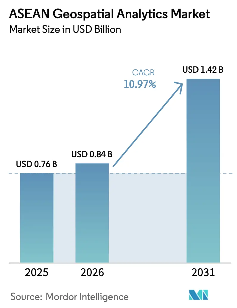
The ASEAN Geospatial Analytics Market size is expected to grow from USD 0.76 billion in 2025 to USD 0.84 billion in 2026 and is forecast to reach USD 1.42 billion by 2031 at 10.97% CAGR over 2026-2031. Continual smart-city spending, rapid 5G roll-outs, and stringent sovereign-data rules are widening the addressable customer base while deepening demand for high-volume, low-latency location intelligence. Enterprise buyers are prioritizing cloud-native spatial databases, API-first architectures, and outcome-based contracts that link pricing to project deliverables. Vendors are responding with integrated software-hardware-services bundles, bundled LiDAR-enabled drones, and AI-ready satellite imagery pipelines. Tight labor pools of geospatial data scientists, fragmented spatial data standards, and rising compliance costs under divergent localization regimes temper growth yet also encourage regional specialists to build localization toolkits that global vendors lack.
Key Report Takeaways
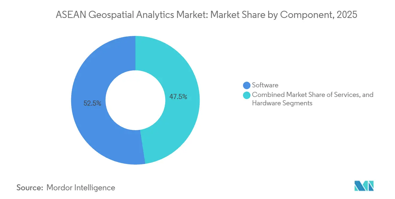
- By component, software captured 52.46% revenue share in 2025, whereas services are expanding at a 12.41% CAGR from 2026 to 2031.
- By application, surface analysis accounted for 38.26% of ASEAN Geospatial Analytics market size in 2025 and spatial AI is advancing at a 13.17% CAGR through 2031.
- By end-user vertical, government and public safety held 26.72% share in 2025, while healthcare records the fastest growth at 12.56% CAGR to 2031.
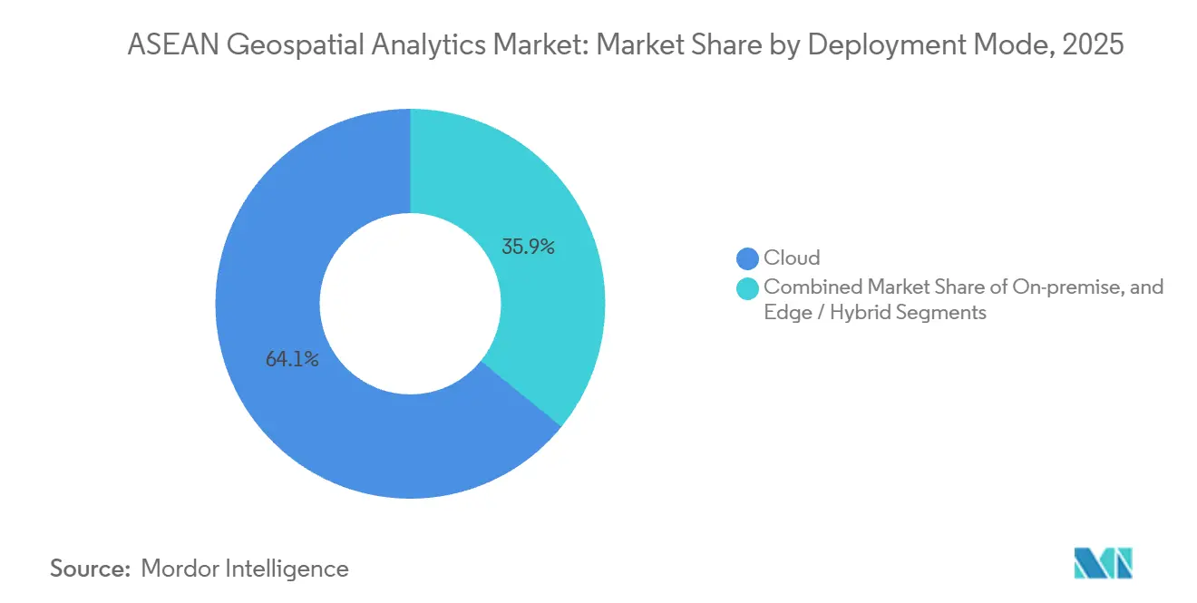
- By deployment mode, cloud commanded 64.13% share in 2025 and edge–hybrid architectures are growing at an 11.43% CAGR to 2031.
- By technology, GIS platforms led with 41.16% share in 2025; LiDAR adoption is accelerating at a 12.36% CAGR through 2031.
- By geography, Singapore led with 22.63% of ASEAN Geospatial Analytics market share in 2025 while Indonesia is forecast to grow at a 13.02% CAGR through 2031.
Note: Market size and forecast figures in this report are generated using Mordor Intelligence’s proprietary estimation framework, updated with the latest available data and insights as of January 2026.
Market Trends and Insights
Drivers Impact Analysis of ASEAN Geospatial Analytics Market*
| Driver | (~) % Impact on CAGR Forecast | Geographic Relevance | Impact Timeline |
|---|---|---|---|
| Smart-city Investment Surge Across ASEAN Capitals | +2.3% | Indonesia, Thailand, Vietnam, Philippines, with early gains in Jakarta, Bangkok, Hanoi, Manila | Medium term (2-4 years) |
| Rapid 5G Roll-out Unlocking High-volume, Low-latency Location Data | +2.1% | Singapore, Malaysia, Thailand, Indonesia, with spillover to Vietnam and Philippines | Short term (≤ 2 years) |
| National Geospatial Data-sharing Mandates (e.g., Thailand GISTDA) | +1.8% | Thailand, Malaysia, Singapore, Indonesia, with pilot programs in Cambodia and Laos | Medium term (2-4 years) |
| ESG-linked Infrastructure Funding Favouring Geospatial Monitoring | +1.5% | Global, with concentrated activity in Indonesia, Malaysia, Thailand for forestry and coastal projects | Long term (≥ 4 years) |
| AI-ready Satellite Constellations Slashing Image Refresh Cycles | +1.9% | Global, with regional ground stations in Singapore, Thailand, Indonesia | Short term (≤ 2 years) |
| Indigenous GovTech Platforms Catalysing Local Analytics Ecosystems | +1.4% | Indonesia, Singapore, Malaysia, Thailand, with emerging traction in Vietnam and Philippines | Medium term (2-4 years) |
| Source: Mordor Intelligence | |||
Smart-city Investment Surge Across ASEAN Capitals
Municipal governments are placing geospatial dashboards at the core of city-operations centers. Jakarta’s unified spatial portal reduced emergency-response times by 18% in 2025. Thailand’s Eastern Economic Corridor earmarked THB 1.5 trillion (USD 42.9 billion) through 2027 for projects that must run pre-build impact assessments using LiDAR-derived digital twins. Hanoi approved USD 1.2 billion for a 3D digital-twin initiative that guides zoning revisions. The ASEAN Smart Cities Network issued 2025 interoperability guidance that references OGC WMS and GeoJSON, lowering vendor integration costs. Indonesia’s USD 33 billion Nusantara capital builds drone-based photogrammetry into every construction phase.
Rapid 5G Roll-out Unlocking High-volume, Low-latency Location Data
Completed nationwide 5G coverage in Singapore delivers sub-10 millisecond latency, letting construction firms stream LiDAR point clouds in real time.[1] Malaysia reached 80% population coverage by December 2024, enabling geofenced fleet optimization in Kuala Lumpur. Thailand auctioned 26 GHz spectrum in 2024 and now supports precision-agriculture pilots that cut pesticide use by 12%. Vietnam subsidized 5G base stations in industrial parks where drones audit inventory without Wi-Fi dependencies. The Philippines mandates 5G in disaster-prone municipalities by 2026, supporting rapid drone imagery uploads after typhoons.
National Geospatial Data-sharing Mandates
Thailand’s One Map platform consolidated 47 agency layers and logged 2.3 million API calls in its first year. Malaysia obliges federally funded projects to deposit as-built data into the MyGDI portal, establishing a living digital twin. Singapore’s Geospatial Master Plan 2.0 commits to releasing 3D underground utility data as open datasets by 2027. Indonesia’s roadmap harmonizes provincial land-use maps, trimming permit delays by 14 months.
AI-ready Satellite Constellations Slashing Image Refresh Cycles
Planet Labs’ Pelican-2 fleet delivers 30 centimeter imagery and on-board change detection within four hours, letting forestry agencies dispatch crews before illegal loggers move on. Satellogic’s NextGen constellation flags new building footprints that Indonesian tax assessors import weekly. ESA’s Φsat-2 mission showed real-time cloud masking, a template ASEAN maritime agencies want for illegal-fishing surveillance. Thailand’s THEOS-2A now provides 2 meter imagery plus biomass analytics that support Paris-Agreement tracking.
Restraints Impact Analysis of ASEAN Geospatial Analytics Market*
| Restraint | (~) % Impact on CAGR Forecast | Geographic Relevance | Impact Timeline |
|---|---|---|---|
| High-performance GPU/CPU Costs for Real-time Analytics | -1.2% | Global, with acute pressure in Cambodia, Laos, Myanmar due to limited public-sector IT budgets | Short term (≤ 2 years) |
| Fragmented Spatial Data Standards Among ASEAN Member States | -1.0% | Regional, affecting cross-border projects in Mekong subregion and BIMP-EAGA corridors | Medium term (2-4 years) |
| Shortage of Domain-specific Geospatial Data Scientists | -0.9% | Indonesia, Philippines, Vietnam, Thailand, with emerging training programs in Singapore and Malaysia | Long term (≥ 4 years) |
| Heightened Data-sovereignty Rules Limiting Cross-border Datasets | -0.8% | Indonesia, Vietnam, Thailand, Malaysia, with bilateral data-sharing agreements under negotiation | Medium term (2-4 years) |
| Source: Mordor Intelligence | |||
High-performance GPU or CPU Costs for Real-time Analytics
A single regional land-cover run on Google Earth Engine can cost USD 200, consuming nearly half of an average Cambodian municipal IT budget. An NVIDIA A100 unit retails at USD 10,000, pushing a basic 16-GPU cluster beyond USD 200,000. Government utilization studies show only 42% GPU use, meaning agencies overpay for idle capacity.[2] While cloud GPU rentals like V100 instances lower capex, recurring bills still strain multi-year budgets.
Fragmented Spatial Data Standards Among ASEAN Member States
Thailand, Malaysia, and Indonesia each rely on legacy datums that introduce up to 5 meter positional errors when cross-border data merge. The ASEAN Connectivity Plan named geospatial interoperability a priority yet funded no pilots. The Mekong River Commission reported six-hour flood-warning delays in 2024 because inconsistent elevation models impaired forecasting. OGC’s Southeast Asia Forum urged adoption of ISO 19115 metadata, but uptake is voluntary.
*Our forecasts treat driver/restraint impacts as directional, not additive. The impact forecasts reflect baseline growth, mix effects, and variable interactions.
ASEAN Geospatial Analytics Market Segment Analysis
By Component:
Services Outpace Software as Outsourcing RisesServices expanded at a 12.41% CAGR, eclipsing the dominance software maintained with a 52.46% ASEAN Geospatial Analytics market share in 2025. Agencies lacking in-house talent are outsourcing LiDAR flights, satellite-image preprocessing, and custom model-building. Esri Thailand recorded a 23% jump in professional-services bookings during 2025. Hardware remains essential for data capture, with Trimble’s Catalyst DA2 bringing decimeter accuracy to smartphones.
Cloud-native spatial engines such as PostGIS and Oracle Spatial permit elastic scaling during seasonal peaks. Hexagon’s BLK2FLY drone pairs real-time object classification with automated cloud uploads, trimming post-processing by 40%. Vendors increasingly bundle hardware leasing, cloud compute, and professional services under outcome-linked contracts, blurring component boundaries inside the ASEAN Geospatial Analytics market.

By Type:
Spatial AI Redefines Predictive CapabilitiesSpatial AI and predictive modeling are growing at a 13.17% CAGR, rapidly narrowing the gap with surface analysis, which held 38.26% of ASEAN Geospatial Analytics market size in 2025. The Philippine Space Agency achieved 92% accuracy detecting informal settlements via a CNN trained on Planet imagery. HERE Technologies reported 11% delivery-time reductions after embedding real-time traffic into Jakarta logistics routes.
Surface analysis still dominates flood modeling and slope stability, but integration of long-range weather data is turning static terrain models into seasonal simulations. Network analysis now guides electric-utility substation placement in Malaysia. Geo-visualization has leaped into augmented reality, letting Singapore planners superimpose building envelopes on active construction sites.[3] Across ASEAN Geospatial Analytics market deployments, prescriptive AI is advising wildlife-patrol routes based on predictive poaching heatmaps.
By End-User Vertical:
Healthcare Emerges as Growth LeaderGovernment and public safety retained 26.72% ASEAN Geospatial Analytics market share in 2025 thanks to mature land-administration and disaster-response platforms. Healthcare, however, posts the fastest 12.56% CAGR as ministries deploy spatial epidemiology to counter dengue. Thailand’s dengue platform predicts hotspots two weeks ahead with 78% accuracy.
Utilities and telecom operators overlay LiDAR and GNSS data on powerlines and 5G cell planning, cutting outages by 19% in a 2025 Malaysian deployment. Precision-agriculture pilots guided by satellite soil-moisture maps lift rice yields and lower water use in the Mekong Delta. Defense users adopt SAR-based change detection to secure maritime zones, all reinforcing diversified demand streams in the ASEAN Geospatial Analytics market.
By Deployment Mode:
Edge Architectures Gain TractionCloud continues to command 64.13% of ASEAN Geospatial Analytics market share, yet edge and hybrid modes are growing at an 11.43% CAGR as latency-critical IoT workloads shift compute closer to sensors. Singapore’s Land Transport Authority reduced commute times 7% by running object-detection models on Jetson-powered roadside nodes.
Hybrid strategies shuttle historical data to cloud stores while reserving microsecond inference for on-device processing. Hexagon’s HxDR lets field crews stream raw point clouds upward, trigger automated classifications, and receive results on tablets in hours. Containerized GIS stacks now migrate between on-premise and cloud Kubernetes clusters without code changes, future-proofing investments across the ASEAN Geospatial Analytics market.
By Technology:
LiDAR Adoption Accelerates Across VerticalsLiDAR adoption is rising at 12.36% CAGR, shrinking the lead of GIS platforms, which still held 41.16% ASEAN Geospatial Analytics market share in 2025. Trimble’s X12 scanner captures 2.1 million points per second to 600 meters, auto-registering scans in the cloud, and reducing labor by 30%.
GNSS advances deliver decimeter real-time accuracy through QZSS augmentation, fueling autonomous-vehicle pilots across ASEAN. Remote-sensing constellations supply the petabytes that AI models ingest, while Mapbox and Google APIs monetize high-volume consumer location calls, recycling revenue into R&D. Smartphone LiDAR now underpins insurance-claims inspections, signaling consumer devices as the next data-collection frontier for the ASEAN Geospatial Analytics market.
Geography Analysis
Singapore Geospatial Analytics Market
Singapore captured 22.63% ASEAN Geospatial Analytics market share in 2025 on the strength of its geospatial master plan and API-rich national spatial data infrastructure. The Urban Redevelopment Authority operates an interactive 3D city model that simulates shadows, wind, and pedestrian flow to optimize zoning decisions. The Maritime and Port Authority integrates vessel tracks, bathymetry, and weather layers for berth optimization, cutting congestion 14%.
ASEAN Geospatial Analytics Market
Indonesia is forecast to grow at a 13.02% CAGR as the USD 33 billion Nusantara capital embeds location intelligence into every phase of construction. The One Map roadmap harmonizes provincial datasets, trimming permit delays. The Ministry of Agriculture and FAO monitor 2.5 million hectares of rice via satellite, saving 18% irrigation water. Malaysia mandates as-built uploads to MyGDI, forming a national digital twin that planners query for flood-simulation scenarios. Thailand’s One Map logged 2.3 million API queries during its first year, highlighting pent-up demand for authoritative data.
Mainland and Island ASEAN Geospatial Analytics Market
Vietnam allotted USD 150 million for LiDAR surveys of Mekong flood provinces. The Philippines uses Sentinel-2 to flag illegal logging within 24 hours.[4]Cambodia, Laos, and Myanmar remain nascent but benefit from SERVIR training and open-data portals. Divergent data-localization laws rooted in the 2024 ASEAN digital-governance framework increase compliance costs for multinationals, but local specialists leverage familiarity with domestic rules to win tenders across the ASEAN Geospatial Analytics market.
Regulatory Landscape
Regulation in the ASEAN geospatial analytics market is shaped by national data-governance and geospatial-authority rules rather than a single regional regime, which increases compliance complexity for cross-border programs. In Indonesia, Geospatial Information Agency (BIG) Regulation No. 6 of 2025 tightened licensing by applying Risk-Based Business Licensing to geospatial-information businesses and requiring conformity assessment certification, pushing vendors and service providers to formalize quality and competency controls.
Sector-specific mandates also influence solution design and procurement. Indonesia introduced PERMENHUT 2/2026 for the forestry domain, requiring thematic geospatial information (IGT) alignment with basic geospatial information (IGD) standards. That framework increases demand for authoritative basemaps, standardized metadata, and auditable processing pipelines in ESG and land-use monitoring workflows. At the regional level, ASEAN Digital Economy Framework Agreement (DEFA) negotiations, referenced in January 2026 materials, focus on cross-border data flows and interoperability, while the ASEAN Digital Masterplan 2030 highlights digital governance priorities that interact with sovereign-data rules across member states.
Value Chain Analysis
The value chain starts with data acquisition and aggregation (satellite imagery, aerial and drone photogrammetry, LiDAR, GNSS, and in situ sensor feeds). It then moves through preprocessing (orthorectification, point-cloud classification, feature extraction), storage and serving (spatial databases, tile services, and APIs), analytics and modeling (surface analysis, network analysis, and spatial AI), and finally visualization and operationalization in enterprise and government workflows. Integration with nationally managed base geospatial information, such as Indonesia's IGD, is a key control point in ASEAN, since it can govern allowable datums, reference layers, and publishing requirements for downstream applications.
Regional system integrators and specialist providers connect global platforms to localized deployments, often bundling software configuration, data services, and managed operations. Esri (Thailand) Co., Ltd., PT Bhumi Varta Technology (Bvarta), and MappointAsia (Thailand) PCL are examples of local-to-regional players that deliver end-to-end offerings, including GIS distribution and implementation, location intelligence, and high-definition mapping and mobile laser scanning, with delivery frequently anchored in government and infrastructure programs. As buyers adopt cloud and hybrid deployments, the chain increasingly includes cloud infrastructure partners and AI toolchains. At the same time, licensing and conformity requirements, including Indonesia's BIG Regulation No. 6 of 2025, add steps around certification, documentation, and data-handling controls before solutions are accepted into production.
Competitive Landscape
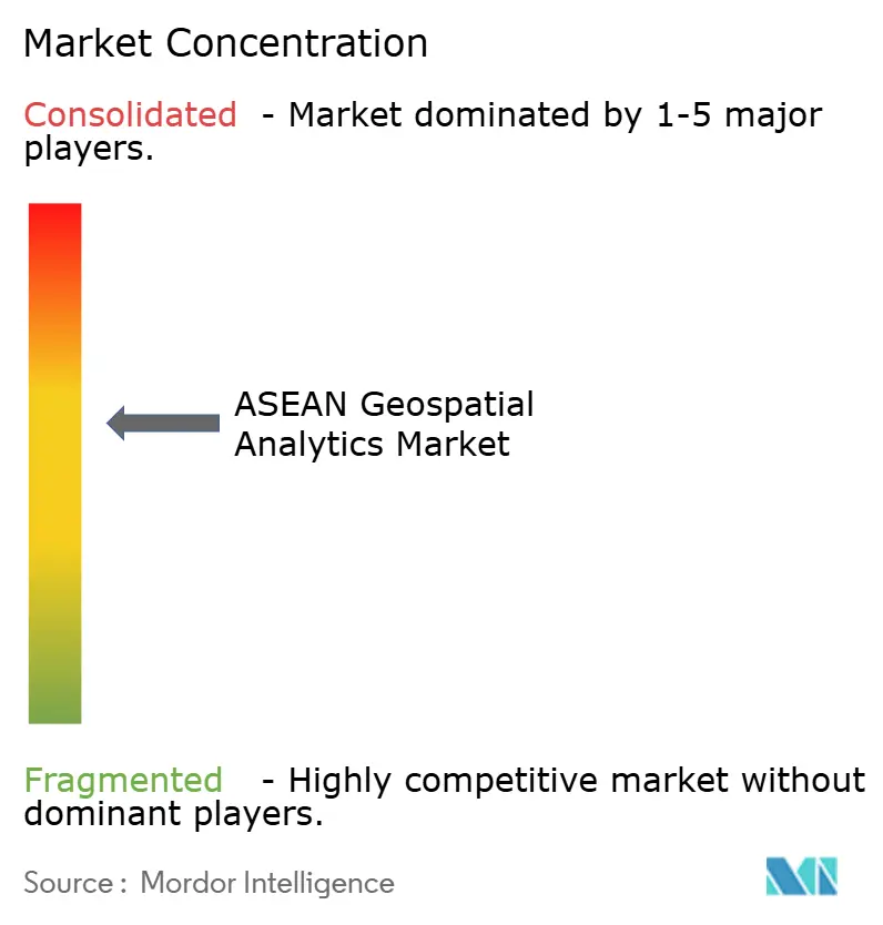
The ASEAN Geospatial Analytics market shows moderate concentration. Hexagon, Esri, and Trimble leverage broad product suites and long-standing enterprise ties. Regional specialists such as Esri Thailand, PT Bhumi Varta Technology, and Geospatial AI Sdn Bhd win government deals by aligning with localization mandates and offering Bahasa-language support. GovTech platforms Onemap.id and Graffiquo expose open APIs that embed directly into national spatial infrastructures, shortening deployment cycles.
Planet Labs and Satellogic differentiate through AI-on-orbit constellations that slash image-to-insight time, giving users near-real-time deforestation alerts. Fugro targets utilities with LiDAR power-line services, reducing outage frequency 19% in a 2025 Malaysian contract. Mapbox dominates consumer location APIs, while Oracle Spatial embeds geospatial joins within ERP backbones, converging IT and GIS stacks.
Patent portfolios raise barriers, Hexagon holds claims over autonomous LiDAR drones, while Trimble dominates multi-frequency GNSS IP. Interoperability pushes from OGC may erode proprietary advantages, encouraging price competition yet expanding addressable markets. Emerging white-space includes edge-inference appliances and low-code spatial AI platforms that mitigate the region’s data-scientist shortage, opportunities that both multinationals and nimble local firms now chase across the ASEAN Geospatial Analytics market.
ASEAN Geospatial Analytics Industry Leaders
-
Hexagon AB
-
Esri (Thailand) Co., Ltd.
-
MappointAsia (Thailand) PCL
-
PT Bhumi Varta Technology
-
Geospatial AI Sdn Bhd (Uzma Berhad)
- *Disclaimer: Major Players sorted in no particular order
ASEAN Geospatial Analytics Market Companies Covered in this Report
- Hexagon AB
- Esri (Thailand) Co., Ltd.
- MappointAsia (Thailand) PCL
- PT Bhumi Varta Technology
- Geospatial AI Sdn Bhd (Uzma Berhad)
- GIS Co., Ltd.
- Intermap Technologies
- Mandalay Technology Co., Ltd.
- Spatialworks Sdn Bhd
- SkyMap Global
- Trimble Inc.
- HERE Technologies
- Maxar Technologies
- Planet Labs PBC
- SuperMap Software Co.
- Google Cloud Geo-Spatial
- Mapbox Inc.
- Alteryx Inc.
- Oracle Spatial
- Fugro N.V.
- Satelligence B.V.
Market Opportunities and Future Outlook
Government-led data unification and interoperability programs create a whitespace for vendors that can productize compliance, metadata, and integration tooling across agencies and countries. In Indonesia, the One Data Indonesia bill moving forward as a House initiative in July 2026 indicates a push to unify geospatial and sectoral data for development planning. That direction favors providers that can connect authoritative basemaps, sector registries, and analytics layers through APIs and role-based access controls. Alongside this, the ASEAN Digital Masterplan 2030 emphasizes combining geospatial data with AI and predictive analytics for public decision-making, which supports demand for packaged spatial-AI workflows that reduce dependence on scarce geospatial data-science talent.
Cross-border digital-economy workstreams also support multi-country architectures that reconcile sovereign-data requirements with shared operational use cases, including logistics, climate-risk monitoring, and disaster response. DEFA negotiations (as referenced in January 2026 reporting) include provisions around cross-border data flows and interoperability standards, and related initiatives such as a Malaysia-led regional framework on cross-border cloud computing provide an implementation pathway for regulated cloud adoption. Vendors that deliver edge-hybrid deployments, localization toolkits (language, datum handling, policy-aligned storage), and auditable processing pipelines are positioned to win programs where procurement increasingly ties acceptance to data-governance readiness rather than analytics features alone.
Recent Industry Developments in ASEAN Geospatial Analytics Market
- June 2026: Esri Thailand partnered with Si Khiu Municipality in Nakhon Ratchasima to implement an ArcGIS-based Smart City platform to integrate urban management data. The launch expands regional data integration and AI-ready spatial workflows within the ASEAN geospatial stack.
- March 2026: Esri Thailand announced a strategy to upgrade its ArcGIS software to a Strategic Location Intelligence Platform, integrating AI and data connectivity. The upgrade signals a platform shift toward AI-enabled location intelligence.
- February 2026: Hexagon AB signed a Memorandum of Understanding with ST Engineering Mission Software and Services unit to pursue public safety sector business opportunities. The collaboration broadens Hexagon's public safety footprint in ASEAN and potential material revenue channel in critical infrastructure projects.
ASEAN Geospatial Analytics Market Report Scope and Research Methodology
Market Definition and Coverage
For this study, the ASEAN geospatial analytics market is defined as revenue generated from software and related services that turn location-based data into insights for business and government decisions across ASEAN countries.
Scope exclusions: This sizing excludes pure data-capture hardware sales (such as satellites, drones, sensors), and it also excludes standalone navigation and consumer mapping apps that do not include analytics work.
Segments Covered in This Report
- By Component
- Software
- Services
- Hardware
- By Type
- Surface Analysis
- Network Analysis
- Geo-visualization
- Spatial AI and Predictive Modelling
- By End-user Vertical
- Government and Public Safety
- Defense and Intelligence
- Utilities and Telecom
- Agriculture
- Mining and Natural Resources
- Real Estate and Construction
- Healthcare
- Automotive and Transportation
- Other End-user Verticals
- By Deployment Mode
- On-premise
- Cloud
- Edge / Hybrid
- By Technology
- GIS
- GPS
- Remote Sensing
- LiDAR
- Web Map Services and APIs
- By Country
- Brunei
- Cambodia
- Indonesia
- Laos
- Malaysia
- Myanmar
- Philippines
- Singapore
- Thailand
- Vietnam
Data Sources, Market Sizing, and Validation
Desk Research
Desk research was used to set the market context and to anchor the model on measurable activity in ASEAN. We reviewed public planning and adoption signals for smart cities, transport digitization, land administration, and disaster risk monitoring, because these areas often fund or trigger analytics spending.
Source inputs were taken from official and open references such as national statistics offices across ASEAN, central bank and finance ministry budget documents, UN data and World Bank indicators, and geospatial or remote sensing publications from government mapping agencies. We also used company annual reports, investor presentations, reputable press coverage, and association websites to cross-check deployments, use cases, and pricing patterns. Where helpful, we referenced paid subscriptions for company financials and intelligence, patent databases, and shipment-level import and export data to verify select assumptions. The sources listed here are illustrative and not exhaustive, and many other public documents were reviewed for data collection, validation, and clarification.
Primary Interviews and Surveys
Primary work focused on validating what is actually being purchased in ASEAN and how contracts are structured across software, implementation, and recurring services. We spoke with a mix of solution users and delivery-side experts, and then used surveys to confirm adoption timing, typical deal sizes, and how usage scales after rollout. Since demand differs by country, feedback was balanced across key ASEAN economies and across public-sector and commercial buying groups.
Distribution of primary research fieldwork respondents
| Company type | Respondent position |
|---|---|
| Top tier: 37% | CXOs: 20% |
| Mid tier: 43% | Functional/Unit leaders: 36% |
| Smaller Players: 20% | Managers: 44% |
Market-Sizing & Forecasting
The market was built using a top-down demand pool, where country-level spending signals and program pipelines were reconstructed into likely geospatial analytics budgets, and then filtered by adoption and outsourcing intensity. This was then checked with selective bottom-up approximations from sampled supplier revenues, typical project counts in key use cases, and observed average selling price bands for software plus services.
Inputs that shaped the model included smart city and e-government project flow, infrastructure and transport digitization budgets, disaster management and climate monitoring investments, cloud migration pace for spatial workloads, and satellite imagery and remote sensing usage growth that feeds analytics demand. In places where vendor revenue splits were not disclosed, gaps were handled by applying conservative attach rates and service-to-software ratios validated through interviews, followed by sensitivity checks.
For forecasting, we used scenario analysis supported by a light multivariate regression on macro and sector indicators, because policy-led spending and project timing can move faster than a smooth historical trend. Assumptions were refined with expert feedback on procurement cycles, localization rules, and expected price progression for analytics subscriptions and implementation services.
Data Validation & Update Cycle
Model outputs were cross-checked against independent signals such as the pace of digital government tenders, cloud adoption markers for enterprise IT, and the visible rollout of geospatial-enabled public programs. Outliers at the country level were reviewed, and if a variance could not be explained by timing or scope, assumptions were revisited and the relevant experts were re-contacted.
Before sign-off, the estimates go through a multi-step review so arithmetic, conversion rates, and growth drivers are consistent across the model. Reports are refreshed annually, and interim updates are made when material events occur (such as major policy changes or large program awards). Right before delivery, we run a fresh pass on key indicators so clients receive the most current view available.
Mordor Intelligence's Asean Geospatial Analytics Market Sizing Compared With Other Published Estimates
Published market sizes for ASEAN geospatial analytics often do not match because each publisher draws the line differently on what counts as analytics revenue and which ASEAN-adjacent demand gets included. Differences also show up when one estimate uses procurement budgets as a proxy, and another uses supplier revenues, which can change the timing of when value is recognized.
Some published figures fold in upstream components like imagery acquisition, sensors, and broader geospatial hardware, which can expand the total quickly. Mordor Intelligence counts only analytics-focused software and related services recognized within ASEAN end-user projects, and it keeps data-capture hardware out to avoid mixing equipment cycles with analytics demand.
Benchmark comparison
| Source | Market Size | Gaps in Research Methodology |
|---|---|---|
| Mordor Intelligence | USD 0.76 B (2025) | |
| Industry Association B | USD 0.94 B (2025) | Often includes a wider set of geospatial spend, especially imagery procurement and monitoring tools sold as packaged programs, which lifts totals beyond analytics-only revenue recognition. |
| Regional Consultancy A | USD 0.62 B (2024) | Uses a conservative budget-led approach with limited adjustment for multi-year project drawdowns and subscription renewals, which can undercount recurring analytics revenue as adoption scales. |
The spread across estimates is mainly explained by what is included beside analytics software and services, and by how spending timing is treated for multi-year public programs. By keeping the sizing tied to clear demand triggers and repeatable checks on pricing and renewal patterns, the final number stays easier to trace and to update as country pipelines change.
Key Questions Answered in the Report
How large is the ASEAN Geospatial Analytics market today?
It stood at USD 0.84 billion in 2026 and is forecast to reach USD 1.42 billion by 2031, reflecting a 10.97% CAGR.
Which country is the biggest adopter of geospatial analytics in ASEAN?
Singapore leads with 22.63% market share thanks to mature digital infrastructure and mandatory data-sharing policies.
Which segment is growing fastest in the region?
Spatial AI and predictive modeling are advancing at a 13.17% CAGR as agencies merge machine-learning with satellite imagery.
Why are services outpacing software sales?
Agencies lacking in-house expertise outsource LiDAR surveys, image preprocessing, and model development, driving 12.41% CAGR in services.
What is the main barrier to cross-border geospatial projects?
Divergent spatial data standards among member states add positional errors and raise compliance costs for regional initiatives.
How are 5G networks influencing geospatial applications?
Sub-10 millisecond latency enables real-time LiDAR streaming, AR navigation, and instant drone imagery uploads for disaster response.