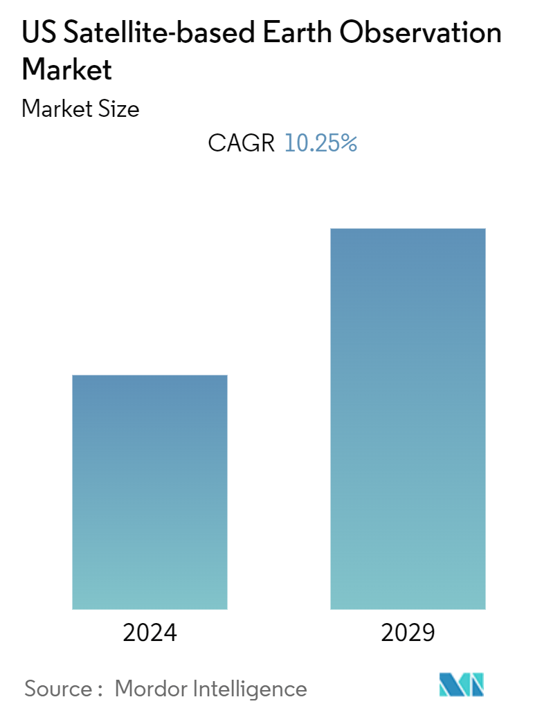
US Satellite-based Earth Observation Market Size
| Study Period | 2019 - 2029 |
| Base Year For Estimation | 2023 |
| Forecast Data Period | 2024 - 2029 |
| Historical Data Period | 2019 - 2022 |
| CAGR (2024 - 2029) | 10.25 % |
| Market Concentration | High |
Major Players
*Disclaimer: Major Players sorted in no particular order |
Need a report that reflects how COVID-19 has impacted this market and its growth?
US Satellite-based Earth Observation Market Analysis
The US Satellite-based Earth Observation Market is expected to register a CAGR of 10.25% during the forecast period.
Satellite-based Earth observation has indeed been experiencing a growing demand in recent years, and the United States has been at the forefront of this industry.
- Earth observation satellites aid in resource management, environmental monitoring and protection, humanitarian aid, and long-term development. Satellites used for environmental monitoring, meteorology, mapping, and other non-military functions are also included. These sensors assess air quality, agricultural health, ice thickness, salinity, and other elements.
- With the growing concern about climate change and its impact on the planet, there is a need for accurate and up-to-date data on various environmental parameters. Satellites provide a valuable tool for monitoring changes in the Earth's climate, including temperature patterns, ice cover, sea level rise, deforestation, and more.
- For instance, in December 2022, the National Aeronautics and Space Administration (NASA) launched a USD 1.2 billion satellite with a high-power radar and other sensitive equipment to better examine the flow of the Earth's water and the effects of climate change. Every three weeks, the satellite will measure water height throughout 70% of the Earth, providing a terabyte of data every day.
- The growth of satellite-based data in agriculture will significantly drive the market. Satellite imagery can assist in monitoring agricultural activities, crop health, soil moisture, and vegetation indices. This information is valuable for farmers, policymakers, and researchers in optimizing crop yields, managing water resources, and ensuring food security.
- For instance, in March 2023, NASA announced the introduction of NASA Acres, a program focused on applying Earth observation data to the most critical agricultural and food security concerns confronting American farmers, ranchers, and agrifood systems. It collaborates with agricultural stakeholders across the spectrum to provide Earth observatory-based data and tools that help improve productivity while safeguarding and repairing land, water, the environment, and human health.
US Satellite-based Earth Observation Market Trends
Increasing Use of Satellites for Advanced Environmental Monitoring
- The United States has recently been increasingly utilizing satellite technology for advanced environmental monitoring. Satellites provide valuable data and insights for understanding and managing various aspects of the environment, including climate change, weather patterns, natural disasters, and land use.
- Weather Satellites are an important observational tool for all scales of National Weather Service (NWS) forecasting operations. The satellites provide real-time imagery and data on cloud cover, atmospheric conditions, and other meteorological variables. This information is vital for accurate weather forecasting, severe storm tracking, and issuing timely warnings for events like hurricanes, tornadoes, and blizzards.
- For instance, in 2022, Maxar Technologies, a provider of complete space solutions, was awarded a National Aeronautics and Space Administration (NASA) Phase A research contract for the National Oceanic and Atmospheric Administration's (NOAA) Geostationary Extended Observations (GeoXO) Spacecraft project. Under this project, Maxar will develop necessary mature technologies, conduct analysis on robotic servicing and payload accommodations and spacecraft concept, and help define the potential performance, risks, costs, and development schedule for a three-satellite, next-generation constellation of weather monitoring satellites.
- Moreover, with the growing concern about air quality in the United States, the government in the United States is launching satellites that can measure various air pollutants, including aerosols, ozone, and nitrogen dioxide. This data helps monitor air quality, identify pollution sources, and assess the effectiveness of air pollution control measures. It supports efforts to protect public health and improve the overall quality of the environment.
- Recently in April 2023, NASA initiated a mission to improve air pollution monitoring over North America by partnering with Intelsat communications satellite to launch a satellite to track air pollution hourly.
Earth Observation Satellite is Playing an Important Role in Urban Development
- Urban development and cultural heritage are expected to dominate the market share. Earth observation satellites have emerged as indispensable tools for urban development, playing a vital role in shaping and managing cities in the United States. These high-tech satellites provide a unique vantage point from space, offering valuable data and insights that enable informed decision-making, sustainable planning, and efficient resource management.
- Earth observation satellites have significantly influenced infrastructure development in the US by facilitating precise mapping, monitoring, and analysis. Satellites equipped with advanced imaging sensors capture high-resolution images of urban areas, enabling accurate mapping of existing infrastructure and identification of potential development sites.
- This data helps urban planners, and policymakers make informed decisions regarding land use, transportation networks, and utility infrastructure placement. Additionally, satellite data aids in monitoring the condition of critical infrastructure, such as bridges and roads, by detecting signs of deterioration and enabling timely maintenance.
- Urban transportation planning is another area where Earth observation satellites have proved invaluable. Satellites provide real-time traffic data, including congestion levels, traffic flows, and travel patterns, allowing transportation authorities to optimize traffic management strategies and enhance mobility.
- Satellite data also aids in planning and developing public transportation systems, helping identify high-demand routes and areas needing improved connectivity. Moreover, satellites enable the monitoring of transportation infrastructure projects, facilitating progress tracking and ensuring adherence to timelines and regulations.
- Moreover, Earth observation satellites are instrumental in monitoring and managing the environmental aspects of urban areas. Satellites equipped with specialized sensors capture data on air quality, land cover changes, vegetation health, and water resources, among other parameters.
- This information assists environmental agencies and city planners in assessing the impact of urbanization on the environment, identifying areas prone to pollution, and implementing measures to mitigate environmental degradation. By monitoring urban heat islands, satellites also contribute to developing strategies for heat stress reduction and energy efficiency in cities.
US Satellite-based Earth Observation Industry Overview
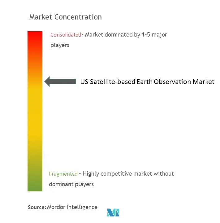
The United States satellite-based Earth observation market is consolidated, with the presence of major players like Airbus Defense and Space, Satcom Technologies, Geo Optics Inc., MDA Corporation (Maxar Technologies), Planet Labs Inc., PlanetIQ LLC, Inmarsat plc., L3Harris Technologies, Inc., Thales Group, Aytheon Technologies Corporation. Players in the market are adopting strategies such as partnerships, innovations, mergers, and acquisitions to enhance their product offerings and gain sustainable competitive advantage.
In December 2022, Planet Labs PBC announced the launch of 36 SuperDove satellites, codenamed Flock 4y, aboard a SpaceX Falcon 9 rocket. These satellites will be added to the company's existing fleet and will strive to provide geospatial solutions to our worldwide client base.
US Satellite-based Earth Observation Market Leaders
-
Airbus Defense and Space
-
Satcom Technologies
-
Geo Optics Inc.
-
MDA Corporation (Maxar Technologies)
-
Planet Labs Inc.
*Disclaimer: Major Players sorted in no particular order
US Satellite-based Earth Observation Market News
- July 2024 - NASA will undertake six activities to meet the Earth observation satellite needs of U.S. Federal civilian agencies. These needs were identified through the 2022 Satellite Needs Working Group (SNWG) biennial survey of Federal agencies and represent high-profile needs for satellite Earth observation data. The SNWG is an initiative of the U.S. Group on Earth Observations (USGEO), which helps coordinate U.S. civilian satellite Earth observations. The SNWG Management Office (SNWG MO) at NASA's Interagency Implementation and Advanced Concepts Team (IMPACT) will oversee these activities.
- November 2023 - India and the US plan to introduce a new satellite for Earth observation called NASA-ISRO Synthetic Aperture Radar (NISAR) in the first quarter of the upcoming year. The S-band SAR from ISRO and L-band SAR from NASA were combined at JPL/NASA and are currently being tested in Bangalore by URSC in collaboration with NASA/JPL officials.
US Satellite-based Earth Observation Market Report - Table of Contents
1. INTRODUCTION
1.1 Study Assumptions and Market Definition
1.2 Scope of the Study
2. RESEARCH METHODOLOGY
3. EXECUTIVE SUMMARY
4. MARKET INSIGHTS
4.1 Market Overview
4.2 Industry Attractiveness - Porter's Five Forces Analysis
4.2.1 Bargaining Power of Buyers
4.2.2 Bargaining Power of Suppliers
4.2.3 Threat of New Entrants
4.2.4 Threat of Substitutes
4.2.5 Intensity of Competitive Rivalry
4.3 Industry Value Chain Analysis
4.4 Assessment of the Impact of COVID-19 on the Market
5. MARKET DYNAMICS
5.1 Market Drivers
5.1.1 Use of Satellites for Advanced Environmental Monitoring
5.1.2 Technological Advancements in Satellite Development and Imagery
5.2 Market Restraints
5.2.1 Increasing Use of Alternative Earth Observation Technologies
6. MARKET SEGMENTATION
6.1 By Type
6.1.1 Earth Observation Data
6.1.2 Value Added Services
6.2 By Satellite Orbit
6.2.1 Low Earth Orbit
6.2.2 Medium Earth Orbit
6.2.3 Geostationary Orbit
6.3 By End-User
6.3.1 Urban Development and Cultural Heritage
6.3.2 Agriculture
6.3.3 Climate Services
6.3.4 Energy and Raw Materials
6.3.5 Infrastructure
6.3.6 Other End-Users
7. COMPETITIVE LANDSCAPE
7.1 Company Profiles
7.1.1 Airbus Defense and Space
7.1.2 Satcom Technologies
7.1.3 Geo Optics Inc.
7.1.4 MDA Corporation (Maxar Technologies)
7.1.5 Planet Labs Inc.
7.1.6 PlanetIQ LLC
7.1.7 Inmarsat plc.
7.1.8 L3Harris Technologies, Inc.
7.1.9 Thales Group
7.1.10 Aytheon Technologies Corporation
- *List Not Exhaustive
7.2 *List Not Exhaustive
8. INVESTMENT ANALYSIS
9. MARKET OPPORTUNITIES AND FUTURE TRENDS
US Satellite-based Earth Observation Industry Segmentation
U.S. Satellite-based earth observation is done with the help of satellites orbiting around the planet to view and identify environmental changes, map making, etc. The satellite-based earth observation technology captures and stores information from satellites relating to the physical, biological, and chemical compositions of the Earth for monitoring, surveillance, and decision-making in various verticals, such as defense and intelligence, infrastructure and engineering, natural resource management, energy and power, and disaster management.
The United States satellite-based earth observation market is segmented by type (earth observation data and value-added services), by satellite orbit (low earth orbit, medium earth orbit, and geostationary orbit), and by end-use(urban development and cultural heritage, agriculture, climate services, energy and raw materials, infrastructure, and other end-users).
The market sizes and forecasts are provided in terms of value (USD) for all the above segments.
| By Type | |
| Earth Observation Data | |
| Value Added Services |
| By Satellite Orbit | |
| Low Earth Orbit | |
| Medium Earth Orbit | |
| Geostationary Orbit |
| By End-User | |
| Urban Development and Cultural Heritage | |
| Agriculture | |
| Climate Services | |
| Energy and Raw Materials | |
| Infrastructure | |
| Other End-Users |
US Satellite-based Earth Observation Market Research Faqs
What is the current US Satellite-based Earth Observation Market size?
The US Satellite-based Earth Observation Market is projected to register a CAGR of 10.25% during the forecast period (2024-2029)
Who are the key players in US Satellite-based Earth Observation Market?
Airbus Defense and Space, Satcom Technologies, Geo Optics Inc., MDA Corporation (Maxar Technologies) and Planet Labs Inc. are the major companies operating in the US Satellite-based Earth Observation Market.
What years does this US Satellite-based Earth Observation Market cover?
The report covers the US Satellite-based Earth Observation Market historical market size for years: 2019, 2020, 2021, 2022 and 2023. The report also forecasts the US Satellite-based Earth Observation Market size for years: 2024, 2025, 2026, 2027, 2028 and 2029.
US Satellite-based Earth Observation Industry Report
Statistics for the 2024 US Satellite-based Earth Observation market share, size and revenue growth rate, created by Mordor Intelligence™ Industry Reports. US Satellite-based Earth Observation analysis includes a market forecast outlook to for 2024 to 2029 and historical overview. Get a sample of this industry analysis as a free report PDF download.
